The Trail
This trail is a loop trail with several different route options along the way. We decided to start our hike going south on the Wild Rose Loop to the Chukkar Loop. We then followed the Chukkar Loop until it met up with the Wild Rose Loop again. The maps below, and the trail information included, follows this path. If you do this route, your trail will be an easy to moderate 2 miles long with a 358 foot elevation change.
 |
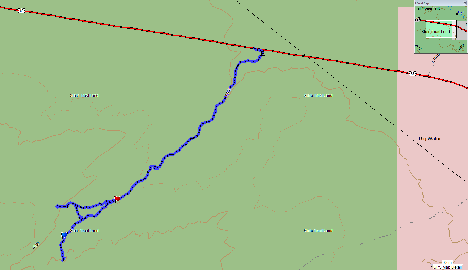
| Topographical Map (Blue = Wild Rose & Chukkar Loop; Red = "View Point" Trail |
 |
| Graph of Elevation |
 |
| Trail in Google Earth (Yellow = Wild Rose & Chukkar Loop; Red = "View Point" Trail |
The trail starts from the park. If you are heading south, you will soon come to a "shortcut" trail (marked by the blue flag in the topographical map). This shortcut will cut off the southern-most section of the Wild Rose Loop if you take it. If you continue on, you will come to a three way split in the trail about 0.3 mile into your trip (marked by a green flag in the topographical map). From here, you can turn and head north to continue the Wild Rose Loop (not shown on map), you can head south along the Chukkar Loop, or you can turn northwest to head out to the view point on the ridge (this section of the trail is in red on the maps above).
 |
| There is lots of wild rose on the south end of the trail |
 |
| First part of Chukkar Loop |
If you continue along the Chukkar or Wild Rose Trails, your path will loop around. The Wild Rose Trail is popular for mountain bikers, but the Chukkar Trail is closed to bikes. You will cross a number of trails that are marked for use by bikes going downhill. There is a turn off at the red flag for the Woodbriar Game and Eagle Ridge Trails. There is an overlook point a little ways past this just off the main trail.
 |
| From the overlook on Wild Rose Loop |
 |
| Looking down toward the trailhead and Wild Rose Park from the overlook |
The trail marked in red on the maps heading to the view point actually continues to
Ensign Peak eventually. The view point is at a bench about 0.3 miles up this section of trail. We only went about 1.3 miles up this section of trail; we didn't have time to go to Ensign Peak.
 |
| Graph of Elevation for the "View Point" Trail |
 |
| "View Point" Trail |
 |
| View from near the bench "view point" |
Dogs are permitted on these trails. Just be sure to clean up after your dog! You can
go here for a more complete map of these trails.
Directions
This trail is located in Davis County in North Salt Lake. If you are coming from north of North Salt Lake City, take I-15 to exit 314. Turn left onto Center Street and then turn right when you reach 130 East. Turn right again at Orchard Dr. When you reach the traffic circle, take the third exit onto Eagle Ridge Dr. Continue 1.6 miles up this windy road and then turn right onto Eagle Pointe Dr. Last, turn left onto Sky Crest Lane and continue until you reach Wild Rose Trailhead Park at the end of the road.
If you are coming from south of the area, take I-15 to exit 312. Continue along Hwy 89 to Eagle Ridge Dr. Turn right, and go straight at the traffic circle. Continue from Eagle Ridge Drive to the Wild Rose Trailhead Park, as explained above.