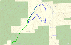
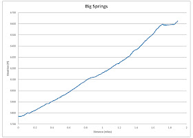
There are a number of trail options starting from this trailhead. Hiking to Big Springs gives your hike a nice end point after a fairly short, moderate trail. Going along the most direct route, shown in green below, the trail is only 1.9 miles long (one way) with a 855 foot elevation change. Alternatively, you can head out on the trail to the east of the parking area. In about a third of a mile after heading up a hillside, hikers will come to a large meadow. This trail crosses the meadow, loops around, and comes to a split with an option to turn off with a possible route from there to Big Springs. Alternatively, by keeping north, the trail will loop around back to the main trail to Big Springs with some spectacular views along the way. The loop (as shown in blue) is about 2.7 miles long with a 530 foot elevation change.
 |
| Topographical Map - green=Big Springs Trail; blue=Loop |
 |
| Graph of Elevation for Big Spring Trail |
 |
| Graph of Elevation for Loop |
 |
| Trail in Google Earth |
Both of these trails are great during the winter with relatively low avalanche danger. When there is a good snowfall, this trail is an excellent snowshoeing trail.
 |
| Trailhead for Big Springs Trail |
The Big Springs Trail follows the creek much of the way. There are a number turn offs, almost all of which just loop back to the same main trail to Big Springs. Some signs along the way help as well. The last sign we saw before the springs was a split between the horse parking area and the way to the Springs.
 |
| Last sign before reaching the Springs |
The Springs are not particularly easy to spot in the winter, but they are easy enough to see during other times of year. If you continue along the trail passed the springs, you will be on the Cascade Saddle Trail. The trail shown in the maps above actually continue just passed the spring.
Those taking the loop trail will experience a fantastic tromp through an open meadow at the top of the first climb.
 |
| Meadow |
The trail curves back after the meadow before heading in a southwest direction and descending toward the creek. The views right before this descent are fantastic.
These trails are open to dogs and livestock. Restrooms are available near the trailhead, but may be closed during winter.
Directions
This trail is located in Utah County. To get to the trail, take exit 272 off of I-15 for 800 North in Orem. Head east along 800 North until the road splits. Take the left fork to head up Provo Canyon. Continue up the canyon for about 5.8 miles, and then turn right onto South Fork Road (toward Vivian park). Drive up South Fork Road for about 3.3 miles, then turn right onto Spring Hollow Road. You will find yourself in a park. If you drive up to the end of this road past the restrooms, there will be a large parking area. The trail starts along the west side of this lot. GPS Coordinates: N40 19.921 W111 31.472


No comments:
Post a Comment