The Trail
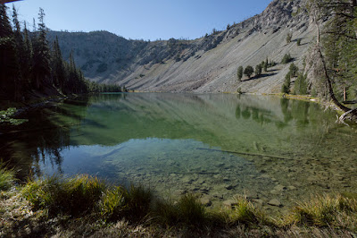
This moderate trail is roughly 2.6 miles one way with about a 1500 ft elevation change. It follows the stream in a climb up to two picturesque mountain lakes.
 |
| Topographical Map |
 |
| Graph of Elevation |
 |
| Trail in Google Earth |
This trail starts crossing a bridge before ascending through pine forest nestled between the walls of jagged cliffs and mountain slopes, leaving hikers with satisfying scenery throughout the trail.
Very near the beginning of the trail, there is a split between the Norton Lakes Trail (7135) and the Norton-Prairie Trail (7134). To just do the Norton Lakes Trail, head left. If you are up for a longer trail, you could continue past Norton Lakes to Miner Lake and Prairie Lake and then loop back along the Norton-Prairie Trail, creating a 10 mile long loop hike. For a more complete map of these trails, see the topographical map here.
 |
| Split between the Norton Lakes Trail (7135) and the Norton-Prairie Trail (7134) |
The trail runs near the stream for a fair amount of the hike, and there is a crossing over some logs that is probably extremely wet earlier in the year.
After hiking about 2.2 miles up the trial, you will arrive at the first lake.
Upper Norton Lake is only 0.3 miles further up the trail.
A trail skirts the south end of this lake, so we walked along it for a ways to enjoy the lake from some different angles.
From here you can head further up the mountainside trail toward Norton Peak and then descend to Miner Lake, or you can head back down the way you came.
This trail is open to dogs, but they must be kept on leash. No toilets were available at the trailhead at the time we did this trail, but vault toilets are scheduled to be install during the summer of 2024.
Directions
This trail is located in the Sawtooth
National Recreation Area near
Sun Valley, Idaho. To get here, take ID-75 north until you reach Baker
Creek Rd. on your left. Continue to Norton Creek Rd., which will be on
your right, and turn up here. Continue to the end of the road, where you
will find the trailhead.


No comments:
Post a Comment