November 11, 2022

Sheep Shelter Trail

The Trail

This super short trail is only about 0.15 miles round trip with about a 50 foot elevation change. It goes a short way up the hillside to a small cave across from the parking area.

Topographical Map

Graph of Elevation

Trail in Google Earth


Across the road from the parking area one can also see the Indian Blanket pictograph up on the rocky hillside.


After crossing the wide dirt path, continue up the hillside to the cave. A sign labels the trail.

Because the images here are facing the back of the cave, a mirror has been placed so they are visible.


Directions

This trail is located in Fremont Indian State Park in Sevier County, Utah. To get there, take Exit 17 off of I-70. Turn west and then turn right at the next two T-intersections. The trailhead here will be on the left about 1.5 miles past the Visitor's Center. Because this trail is in a state park, there is a fee for visiting and using the trails.

GPS Coordinates: N38° 34.782' W112° 18.566'


Cave of 100 Hands

The Trail

This easy trail is pretty flat with about a 20 ft elevation change in 0.3 miles (one way), making it an doable stroll nearly everyone.

Topographical Map

Graph of Elevation

Trail in Google Earth

This trail starts from a little pull-off parking area. It follows the creek for a short time and heads down under the highway. 


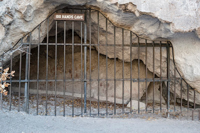
After that, the trail turns more east and heads along the base of the hillside until it arrives at the cave. It does look like there is a trail heading the opposite direction here, so don't turn that way. The cave itself is protected by metal bars to prevent damage to the images. Despite its name, the cave only has 31 hand prints in it.

Trail heading wrong way


Directions

This trail is located in Fremont Indian State Park in Sevier County, Utah. To get there, take Exit 17 off of I-70. Turn west and then turn right at the next two T-intersections. The trailhead here will be on the right about 0.3 miles past the Visitor's Center. Because this trail is in a state park, there is a fee for visiting and using the trails.

GPS Coordinates: N38° 34.722' W112° 19.830'