July 17, 2023

Lewis Peak Trail

The Trail

This difficult trail is 5.2 miles long (one way) with about a 1800 ft elevation gain. That being said, there is a fair amount of up and down that increases the overall amount of climbing along the trail. The first 2.6 miles is a fairly steady climb up, but the rest of the way to the peak involves both assents and descents.

Topographical Map

Topographical Map of first part of trail

Topographical Map of latter part of trail

Graph of Elevation (avoiding extra peaks)

Trail in Google Earth

This trail start at the North Ogden Divide trailhead and heads along the Skyline Trail on the east side of the parking lot.


The trail ascends the mountainside here in a fairly steep climb. If you are looking for a shorter hike, there are some nice views once you reach the ridge along this trail, as marked in the Google Earth image. It is about 1.6 miles with just over a 1400 foot climb to this point. This trail is particularly colorful in the fall.


After reaching the ridge, the trees thin and the views open up more. The trail splits about 2 miles up from the trailhead. This split is labeled, but keep to the right to head up to Lewis Peak. The left trail heads down to Windsurfer Beach.


In about another mile, the trail comes to a junction with the Coldwater Peak Trail (087), which connects with the Skyline trail. 
 

By this point hikers will already have passed a couple spots where there are hills that the trail goes up, with options to go around them too. The options to bypass the peaks are obviously easier with less elevation gain (shown in green, but not reflected in the elevation graph). We ended up going up nearly all of these on the way up and then around them all on our way back. The fourth of these little peaks is Eyrie Peak standing at 8137ft, and it is actually higher than Lewis Peak (8022 ft). 


There is a loop that heads up to Lewis Peak and then back down. We headed around counter clockwise. There is a sign marking the peak at the top.
 

Dogs are permitted on leash on this trail. There are vault toilets at the trailhead.
 
Directions
This hike is located in Weber County Utah. To get there from I-15, take exit 349 onto 2700 N in Farr West. Then turn left onto 1050 E. Continue to 3100 N/North Canyon Rd and turn right. Continue up this road and up the canyon for about 3 miles to the trailhead, which will be on the right. GPS Coordinates: N41° 19.221' W111° 53.947'


April 06, 2023

Fort Rodney and Signal Peak Loop

The Trail

This moderate hike is only 1.2 miles long with about a 300 foot elevation change. Just remember, there is some up and down hiking as you will climb up to the fort, back down, and then up to Signal Peak. For anyone wanting a shorter trek, it's easy to just go to the fort or the peak instead of walking the whole thing.

Graph of Elevation

Trail in Google Earth

We started from the parking lot area and headed west toward the fort first. The trail is smooth wide, and even for most of the way to the fort.

Trail heading toward Fort Rodney

U.S. Signal Station on way to fort

There are ramps and steps up to the fort. There is a little lookout point along the way.


The fort is about 0.4 miles from the parking area. On top there are lovely views and the opportunity to climb down to a room below.
 

Looking out toward Signal Peak


If you would like to continue to Signal Peak, go back down the fort and turn left after the signal station. It is about another 0.4 miles to Signal Peak from the fort, with a steeper climb. The trail goes past another few points of interest along the way.
 
Musket Redoubt
 

Trail up to Signal Peak

View from Signal Peak

Looking at Fort Rodney from Signal Peak

Returning to the parking area is about another 0.4 miles from the top of Signal Peak. The trail continues past other structures of interest on its way.


Directions

This trail is located on St. Lucia. To get there, take the Castries - Gros Islet Hwy to the turn off for Pigeon Island. Drive to the parking lot. GPS Coordinates: N14° 05.555' W60° 57.745'


April 03, 2023

Caneel Trail

The Trail

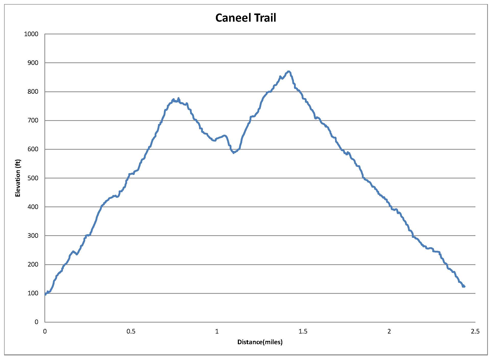
This moderate 2.4 mile trail (one way) has about a 775 ft elevation change. It boosts some nice views of the island and surrounding bays from several points along the trail.

Trail Map

Graph of Elevation

Trail in Google Earth

We started this trail by walking along the road to the trailhead from the visitor's center. The trail is well marked and easy to  find. It climbs up the hill for about 0.7 miles to the top where a small lookout tower and bench sit. We noticed many interesting plants along the way too.


Bench at top of hill

Lookout at top of hill
 
 
From here, the trail continues along the ridge for about another 0.3 miles before reaching the Tamarind Trail heading down the hill to the road below. We continued along the Caneel Trail though, which eventually heads down to the road below too. It does intersect with the Water Catchment Trail, which can be followed instead for a slightly larger loop if desired. The trails are marked well with signs at the intersections. The trail ends at the road where another trailhead sign labels it here.


Trailhead at far side of Caneel Trail coming out to road
 

Directions

From the dock where the ferry stops, head past the visitor's center and out to North Shore Rd. Follow this road northeast and continue through the curve northward. The trail starts at the end of this curve and is clearly marked. GPS Coordinates: N18° 20.001' W64° 47.504'