June 20, 2012

Lower Calf Creek Falls

The Trail


This popular trail is a moderate 3 miles (one way). There is only a 170 foot elevation change, but the trail goes up and down a fair amount within that. The trail also has a lot of sections of deep sand, which can be tiring to hike through. The more weight you are carrying, the more strenuous these sections are to hike through.

Topographical Map

Graph of Elevation

Trail in Google Earth

The trail actually starts down a road for a campground but quickly heads off from there as a dirt and sand path. There isn't a great deal of shade on the trail, but the amount can vary depending on the time you go.

There is plenty to see of interest along the trail, from the beautifully formed rocks and canyon walls streaked with desert varnish, to the bright wildflowers and plant life. There are beaver dams, some Indian petroglyphs (view point for those marked by green dot on the topographical map), ancient granaries built into the canyon walls, and a variety of birds (making the area popular for bird watching). Hikers can pick up a trail guide available at the beginning of the trail that will point out some of these things along the way.


Prickly Pear Cactus

Petroglyphs on canyon wall across from the trail

Desert Varnish streaked on
canyon walls


The trail flattens out some right before hikers reach the waterfall. Before arriving at its base, the top of the waterfall is visible above the trees.

First view of waterfall from trail

The waterfall itself cascades down a 126 foot drop, and its path is highlighted by bright green algae growing on the rocks. The cold calm water filling the pool below the falls creates a popular swimming spot. There is a small sandy beach area around the pool surrounded by a number of trees that provide shade on the sidelines.

Lower Calf Creek Falls

Note: When we did this trail, we found the parking lot for it was not made well and can be very messy when it is hot. When it heats up, there are patches of sticky tar all over that gets stuck on the bottom of your shoes.


Alcove near falls
Directions

This trail is located in Garfield County in the Grand Staircase-Escalante National Monument. The trail is right off UT-12. To get there from I-15, take Exit 188 to get onto US-50. Get off US-50 at UT-260. From there get onto UT-24 and continue to UT-12. Turn right onto UT-12 and continue 48 miles to the "Calf Creek recreation Area." Turn right to drive down into the parking lot. There is a small fee to park here and use the area ($2.00 as of 2012 for day use).

June 19, 2012

Rim Overlook/Navajo Knobs Trail

The Trail


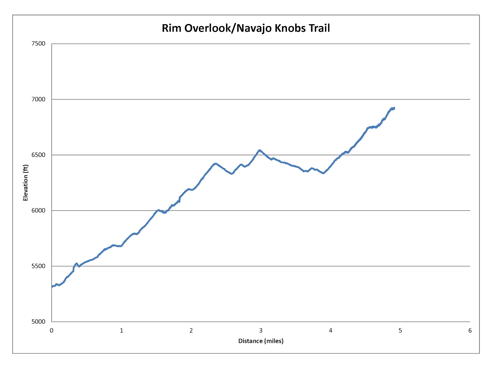
This difficult trail is 4.9 miles long (one way) with a 1613 foot elevation change. However, keep in mind that there is some up and down in the trail (see the elevation profile below). This trail shares a trail head with the Hickman Bridge Trail. The trail splits about .3 mile up from the trail head (marked with a blue flag on the topographical map below). To just do the Navajo Knobs trail, stay to the right. For those who want to hike the Hickman Bridge Trail as a side trip too, your round trip hike will be about 11 miles long.


Topographical Map
Graph of Elevation

Trail in Google Earth

This trail is very exposed with no shade, making it a hot, dry trip, especially during the summer. Make sure you bring ample water with you and cover up and/or wear plenty of sunscreen. However, hikers are rewarded for their efforts with some spectacular views. There are also a lot of cool rock formations along the trail that add additional interest along the way.

Pectols Pyramid


It is important to stay on the trail and off the dirt so as not to disturb the cryptobiotic crust. The trail is easy to follow. Where dirt paths disappear on the rocks, rock cairns are easy to spot marking the way.

This rock cairn is made with a log of petrified
wood at its base

There are actually three specific viewpoints found along the trail. The first is a view of the Hickman Bridge. Hikers will get a much better view of this natural bridge from the Hickman Bridge Trail since it is partially obscured from this view point.

Hickman Bridge from viewpoint


The second viewpoint is the Rim Overlook (marked by the green flag on the topographical map). From here hikers get a great view of Fruita below and the canyons surrounding the historic settlement. 

View from Rim Overlook

Another view from Rim Overlook

The fruit trees growing in Fruita

From Rim Overlook

From the Rim Overlook, the trail heads northward for a ways immediately to the east of The Castle. Then toward the latter end, the trail heads more westward as it winds up and down a couple jutting rims before ascending to its finish next to the Navajo Knobs.

The Castle

The Castle


The last portions of the trail involve hiking up and down some slickrock fields along the canyon rims.

Climbing up the slickrock

Looking back at one of the rims the trail follows up and then back down


Right before reaching the top hikers see this little arch


The views from the end of the trail are fantastic! Hikers can see canyons, mountains, rocks, and valleys for miles around. The pictures just can't do it justice.

View from the top looking southeast

View from the top looking northwest

Looking back at Navajo Knobs (circled) from across the way

Directions

This trail is located in Capitol Reef National Park in Wayne County, Utah. The trail is right off UT-24. To get there from I-15, take Exit 188 to get onto US-50. Get off US-50 at UT-260. From there get onto UT-24 and continue to Capitol Reef and the trail head, which will be on the left.

June 01, 2012

Taylor Canyon Trail


The Trail

This moderate trail has a 1335 foot elevation change. The Taylor Canyon trail itself is supposed to be about 1.4 miles long (one way), but to get to it you have to take a short walk up to where it starts that is about 0.4 miles long. In total, we went just over 1.7 miles up before we turned around, but we didn't quite reach the end of the trail. The trail is supposed to dead-end and fade out, much like the Coldwater Creek Trail. The trail was getting rougher and rougher by the end, and we don't suspect it went up very much further.

About a mile from the trail head you will come to a turn-off that heads up the Malan's Peak/Basin Trail (marked by the green dot on the topographical map below). Keep going straight up the canyon to stay on the Taylor Creek Trail. The green tent on the Topographical Map marks a camping spot along the trail.

Topographical Map

Graph of Elevation

Trail in Google Earth

Beginning of the Trail from 27th Street Trailhead


The trail splits in two different directions soon after the trail head, but either way you go will take you to the Taylor Canyon Trail. Both routes first lead to the Bonneville Shoreline Trail. From there, follow signs along the way directing you to the Taylor Canyon Trail.

Follow signs such as this to find the correct trail

The trail follows the creek much of the way up and is mostly shaded, making for a very pleasant hike. Overall, the trail gradually gets a bit steeper as you go up, but for the most part the climb is fairly steady and even. Toward the end of the trail, the path flattens out briefly. At this point, the foliage opens up some for awhile allowing glimpses of Mount Ogden through the trees and nice views of the surrounding canyon slopes.


On our way back down we caught some quick views of the valley below. However, the valley is pretty hidden during most of the duration of the trail.

View of Valley

Dogs are allowed on this trail if they are kept on a leash.


Directions

This trail is located in Weber County. To get there, from I-15 take Exit 341 for 31st Street in Ogden. Head east on 31st Street until you reach Washington Blvd. Turn left on Washington, and then take the next right onto 30th Street. Continue to Harrison Blvd. and turn left. Then continue to 27th Street and turn right. Continue until the street dead-ends. This is where the trail starts. There is no parking lot, so you will have to park along the street. Please be respectful to the residents and their properties near the trail head.


May 10, 2012

Little Ruin Canyon Trail

Stronghold House
The Trail


This easy loop trail is 1.5 miles long (round trip) with an optional turnout to Tower Point that adds approximately an extra half mile to the trail. Most of the trail is fairly flat, but there is a steeper area at the end of the loop into the canyon and then back out.

The trail passes a number of Indian ruins along the canyon edge built around 1230 to 1275 A.D. constructed in various shapes and sizes. While there are various theories on their uses, the real purpose of these buildings is unknown. To view a trail map and to read more about the specific ruins along the trail, see this PDF of the trail guide. You can also pick up a trail guide at the visitor's center.


Twin Towers, Rim Rock House, and Eroded Boulder House

Eroded Boulder House

Twin Towers
 

Hovenweep Castle
While viewing the archeological sites, it is important to stay only on designated trails. Stay off of and do not touch the ruins. Do not bring food or leave trash near the ruins as this attracts burrowing rodents that further unstabilize the fragile ruins. Pets are allowed on this trail if they are kept on a leash no longer than 6 feet long.


Hovenweep Castle from across canyon

Looking up at Stronghold House from bottom of canyon

Further along the road past the visitor's center, you can find additional ruins of interest. Contact the park for further information. You can find a map of these areas here.

Square Tower
Directions

This trail is located at Hovenweep National Monument along the Utah Colorado border. If you are coming from the west, from US-191, turn onto US-262/Hovenweep Rd. Continue to Reservation Rd., then turn right. Turn left onto C R 413. Hovenweep will be on the right. The trail starts at the Visitor's Center.

If you are coming from the east, from US-491 N/N turn onto County Rd. CC. Next, turn left onto Co Rd. 10 and continue until you reach Hovenweep on your left.