July 09, 2015

Fantasy Canyon

The Trail
This easy trail is only about 0.6 mile round trip with only about a 90 foot elevation change. This canyon if full of intricate and wild rock forms. Some of these delicate structures have been given names based on things they resemble, but it is also a fun place to use your imagination to find additional shapes and objects hidden among the crazy and ever changing rocks.

Topographical Map

Graph of Elevation

Trail in Google Earth

Camel
While there are signs warning visitor's to stay on the trail, we found the trail to be a little difficult to follow in places. Our own path didn't end up quite matching the trail maps at the beginning of the trail or found online here. That being said, staying on the trail as much as possible is important, and staying off the delicate rock formations is particularly necessary since they are fragile and will break easily. Please note that the trail information above follows the route shown on the map from the north most point, down around the first loop, then east and down over to the second loop, and then back up to the southern point at the parking area.

Witch

Coyote

Rooster

Gargoyle


The map linked to above also shows where the various rock forms along the canyon are located. Additionally, metal stakes mark these forms along the trail. However, some of them were more obvious than others. While we found a number of them, we were unable to see others.

Here you can see the metal stakes at the canyon's base marking rock forms

This trail starts from a large dirt parking lot. There is a vault toilet available here and a picnic bench next to a map of the trail, but nothing else. There is little to no shade in this area.

Directions
This trail is located in Uintah County near Vernal, Utah. It is actually out in the middle of "nowhere" and takes awhile to get to. From Vernal, travel east on US-40, following it around as it curves south, and then turn right onto to US-45. Continue south/south-east on US-45 for about 20.3 miles, and then turn right onto Glen Bench Rd. Continue along Glen Bench Rd. for about 12.8 miles (and watch out for prairie dogs along the road through here), and then turn left/east onto Coyote Washinton Rd. This is a dirt road, and there are lots of turn offs from it along the way, but if you continue to follow it for about 4 to 4.5 miles, you will come to Fantasy Canyon. Signs along the way will further direct you there.

July 07, 2015

Hog and Box Canyon Trails

The Trails
This post is actually about two very short and easy out-and-back trails right next to each other in the Dinosaur National Monument. The Hog Canyon Trail is roughly .8 mile long one way while the Box Canyon Trail is about .3 mile one way.

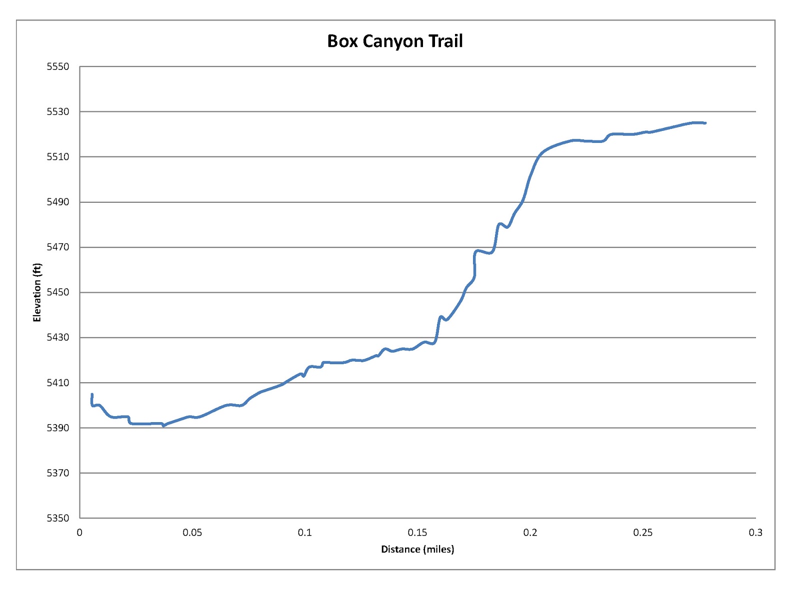
Both trails end where the rocks get steep, but it is possible for more adventurous hikers to continue climbing up the canyons where the trail ends. This is particularly true of Hog Canyon, which continues north much further. We did climb up both canyons a short way from where the trail ended, and this is reflected some in the maps and graphs below. The main trails are actually very flat if you decide not to climb up past where they end. Exploring off trail is permissible in Dinosaur National Park, so long as leave no trace practices are used.

Please note that the trail information as displayed in the maps and graphs below are only rough approximations due to the fact that our GPS did not function well in these deep canyons.

Topographical Map (blue = Hog Canyon; red = Box Canyon)

Graph of Elevation for Hog Canyon

Graph of Elevation for Box Canyon

Trails in Google Earth (red = Hog Canyon; yellow = Box Canyon)

The Hog Canyon Trail starts out just west of Josie Basset Morris's cabin, which was a nice home by homesteading standards. This area is the site of her homestead, and she used hog canyon as a natural corral in which to keep her pigs by building a fence at its opening to keep them in.

Josie Morris's cabin

The trail passes Josie's old chicken coop and a small pond she built to retain water.


There are some nice shady spots along the trail. Eventually the trail up the canyon disappears. You can keep climbing up the rocks if you want to continue, or you can turn around and head back. Beware of poison ivy in this area.


Looking down the canyon after climbing some rocks

Looking north up the canyon after climbing up some of the rocks
The Box Canyon Trail starts on the north side of the parking lot, across from the Hog Canyon Trail. This trail goes up into a short canyon that ends abruptly with wall. The trail does not go all the way up to this rock wall, but it is possible to scramble up the rocks to it if you want.

Box Canyon

Looking down Box Canyon from a rock up past where the trail ends

Dogs are not permitted on these trails. There is an outhouse available at the trailhead.

Directions
This trail is located in Uintah County in Dinosaur National Monument near Vernal, Utah. To get there from Vernal, take US-40 east to UT-149. There is a visitor's center at the corner of this intersection. Turn left onto UT-149 and continue to Dinosaur National Monument. There is a a $10 entrance fee/passenger vehicle. Once in the park, continue along the main road (Cub Creek Rd.) until it end and splits up two unpaved roads. Take the left/north fork up the Josie Ranch Rd. until you reach the parking lot. Both trails start from there.

June 08, 2015

Wild Rose/Chukkar Loop Trail

The Trail
This trail is a loop trail with several different route options along the way. We decided to start our hike going south on the Wild Rose Loop to the Chukkar Loop. We then followed the Chukkar Loop until it met up with the Wild Rose Loop again. The maps below, and the trail information included, follows this path.  If you do this route, your trail will be an easy to moderate 2 miles long with a 358 foot elevation change.

Topographical Map (Blue = Wild Rose & Chukkar Loop; Red = "View Point" Trail

Graph of Elevation

Trail in Google Earth (Yellow = Wild Rose & Chukkar Loop; Red = "View Point" Trail

The trail starts from the park. If you are heading south, you will soon come to a "shortcut" trail (marked by the blue flag in the topographical map). This shortcut will cut off the southern-most section of the Wild Rose Loop if you take it. If you continue on, you will come to a three way split in the trail about 0.3 mile into your trip (marked by a green flag in the topographical map). From here, you can turn and head north to continue the Wild Rose Loop (not shown on map), you can head south along the Chukkar Loop, or you can turn northwest to head out to the view point on the ridge (this section of the trail is in red on the maps above).

There is lots of wild rose on the south end of the trail

First part of Chukkar Loop


If you continue along the Chukkar or Wild Rose Trails, your path will loop around. The Wild Rose Trail is popular for mountain bikers, but the Chukkar Trail is closed to bikes. You will cross a number of trails that are marked for use by bikes going downhill. There is a turn off at the red flag for the Woodbriar Game and Eagle Ridge Trails. There is an overlook point a little ways past this just off the main trail.

From the overlook on Wild Rose Loop

Looking down toward the trailhead and Wild Rose Park from the overlook

The trail marked in red on the maps heading to the view point actually continues to Ensign Peak eventually. The view point is at a bench about 0.3 miles up this section of trail. We only went about 1.3 miles up this section of trail; we didn't have time to go to Ensign Peak.

Graph of Elevation for the "View Point" Trail

"View Point" Trail


View from near the bench "view point"


Dogs are permitted on these trails. Just be sure to clean up after your dog! You can go here for a more complete map of these trails.

Directions
This trail is located in Davis County in North Salt Lake. If you are coming from north of North Salt Lake City, take I-15 to exit 314. Turn left onto Center Street and then turn right when you reach 130 East. Turn right again at Orchard Dr. When you reach the traffic circle, take the third exit onto Eagle Ridge Dr. Continue 1.6 miles up this windy road and then turn right onto Eagle Pointe Dr. Last, turn left onto Sky Crest Lane and continue until you reach Wild Rose Trailhead Park at the end of the road.

If you are coming from south of the area, take I-15 to exit 312.  Continue along Hwy 89 to Eagle Ridge Dr. Turn right, and go straight at the traffic circle. Continue from Eagle Ridge Drive to the Wild Rose Trailhead Park, as explained above.

June 02, 2015

Bucktank Draw to Birthday Arch

The Trail
This easy trail is 5.25 miles round trip with a 502 foot elevation change if you do the entire thing. Most of the trail just follows the wash. Going just to the arch is 2.2 miles (one way).

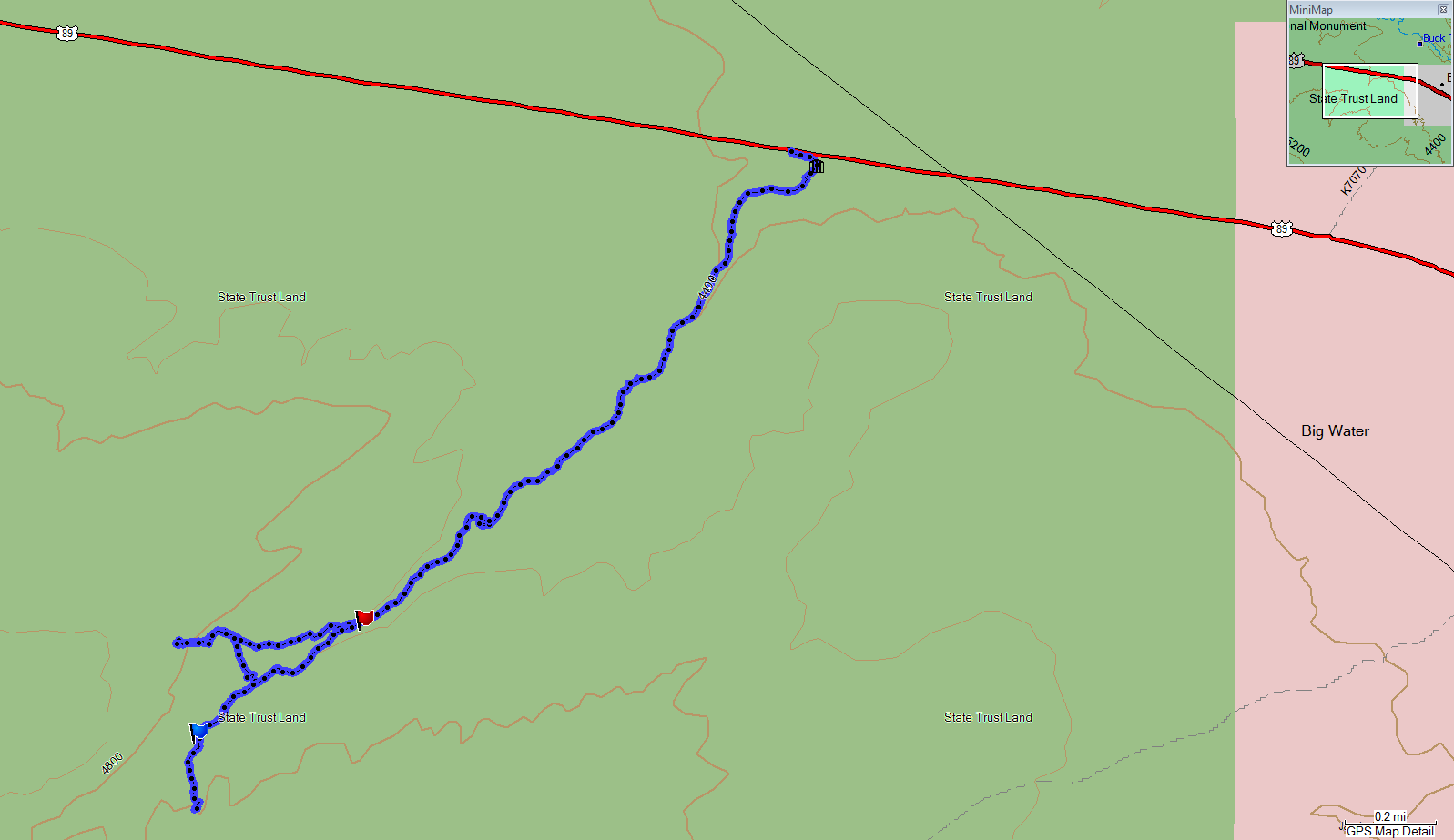
Topographical Map

Graph of Elevation (round trip of entire hike)

Trail in Google Earth

To begin the trail, you first following a path down to a gate and enter a wash. As you walk along this wash, your path will alternate between sand and rock.

Close the gate


As you continue up the wash, you will come to some pour overs. Some of these can be easily climbed, but the larger ones have paths to the right that go up and around them.


You must follow the wash until you see the arch off to your right (west) and then make your way up to it. After leaving the wash, there is no official trail. There is a good place to make your way out of the wash and head toward the arch about 1.8 miles into the hike (marked by a red flag in the topographical map - N37 04.396 W111 43.346).

Arch as seen in distance from the wash

You will have search out a way to get up the rocks right below the arch, but we didn't have any problem finding a doable approach.


Birthday Arch


From the arch, you will be able to see a slot canyon on the opposite side of the wash. If you wish you visit it, you can hike back down to the wash and follow it until it crosses another smaller wash (marked by the blue flag in the topographical map - N37 04.180 W111 43.741) stemming from this slot canyon. It is another .7 mile from the arch to this slot canyon.

The slot canyon is on the left, as seen from the arch

Approaching the slot canyon

The slot canyon is very short and deep. There does not appear to be possibility of continuing up it after you reach the end of this first section, but perhaps if you are an experienced climber you could find a way.


From the slot canyon, you can simply follow the wash back to the trailhead.


Directions
This trail is located in Kane County, Utah at mile 9.75 along Hwy 89. It is about 54 miles from Kanab, and 17.3 miles from the Carl Hayden Visitor's Center near Page, Arizona. Finding the trailhead can be a bit challenging since there is nothing to mark the presence of the trail. You must park on the south side of Hwy 89 at mile 9.75 just on the west of a metal railing there. Since there is no parking lot or sign, it is best to just watch the road mile markers.