September 19, 2018

Sapphire Point Trail

The Trail
This easy trail with only a roughly 65 foot elevation change consists of a short 0.6 mile loop around the crown of a hill overlooking Lake Dillion.

Topographical Map

Graph of Elevation

Trail in Google Earth
 
From the parking area, we started around the trail on the south side where the trailhead sign and bathrooms are, so this is the direction reflected in the elevation information above. The best viewpoint is only about a tenth a mile from this spot.

Trailhead


View from main viewpoint

However, there are plenty of other nice view too as you continue around the loop.


Directions
This hike is located near Frisco, Colorado. To get there from I-70, take Exit 203 for Summit Blvd. and head south on this road. Continue along this road for about 3.7 miles until you reach Swan Mountain Road. Turn left and continue for just under 2 miles to the trailhead. It is an obvious turn out from the main road on the left. GPS Coordinates: N39 35.316 W106 02.660

September 18, 2018

Preston Ghost Town

The Trail
This trail is about 1.6 miles long (one way) with roughly a 444 ft. elevation change. This distance includes going up to see the remains of the old boarding house along the way, but if you don't go up that way, you will cut about 0.3 mile off your trip. Keep in mind that there is some up and down to this trail if you do head up to the boarding house.

Topographical Map

Graph of Elevation

Trail in Google Earth

Preston was once a mining town with about 150 people living there. Gold, silver, and lead were mined there from the 1880s to the 1930s.

The "trail" is really a jeep road that once was a stagecoach road accessing the old mining town of Preston. The first point of interest you will come to is about 0.5 mile up this way is the Jessie Mill, or at least what is left of it. A nearby plaque details some of the history of the mill and boasts a picture of what it once looked like before it was abandoned.


Not far after this point, there is a turn off for Dry Gulch to the left. Soon after that, there is another split in the trail. If you take the south trail to follow the Dry Gulch trail up a short ways, you will reach the old boarding house. There are lots of remnants of the past lying about this area as well...from old bed wires to a rotting wheelbarrow.

Head up this way when you reach the split in the trail

Remnants of old boarding house


After you head back down to the other road, you will continue up it for another 0.7 mile before you arrive at the Extension Mill off to your left. (Before that point you will pass the Old Flume Trail about a half mile after the turn off for the boarding house, shown in red in the trail maps above.) You can walk on the road around this area, but stay out of the mill site; it is dangerous.


About a tenth a mile further up the road are some old homes and a pile of wood that was once a boarding house. Once again, a sign here gives some background.


Old boarding house remains


We didn't go any further than this. However, I believe if you continue up Country Road GH7 at the four way intersection where the boarding house was, you will be able to reach Jumbo Mine at the top of the hill.

This trail is actually a jeep road, so it is open to vehicles as well as dogs. There is an outhouse at the trailhead.

Directions
This trail is located in Colorado near Breckenridge. From Breckenridge, take Highway 9 to Tiger Rd. and turn east. Continue to Highlands Dr. and turn right. Then turn left onto Fairways Dr., which eventually connects to and becomes Glen Eagle Loop. At the end of this road, turn right onto Gold Run Dr. There is a dirt parking lot at the end of the road. Head up the dirt road labeled GH09. GPS Coordinates: N39 30.900 W106 01.589

Head up this road to reach Preston Ghost Town


September 17, 2018

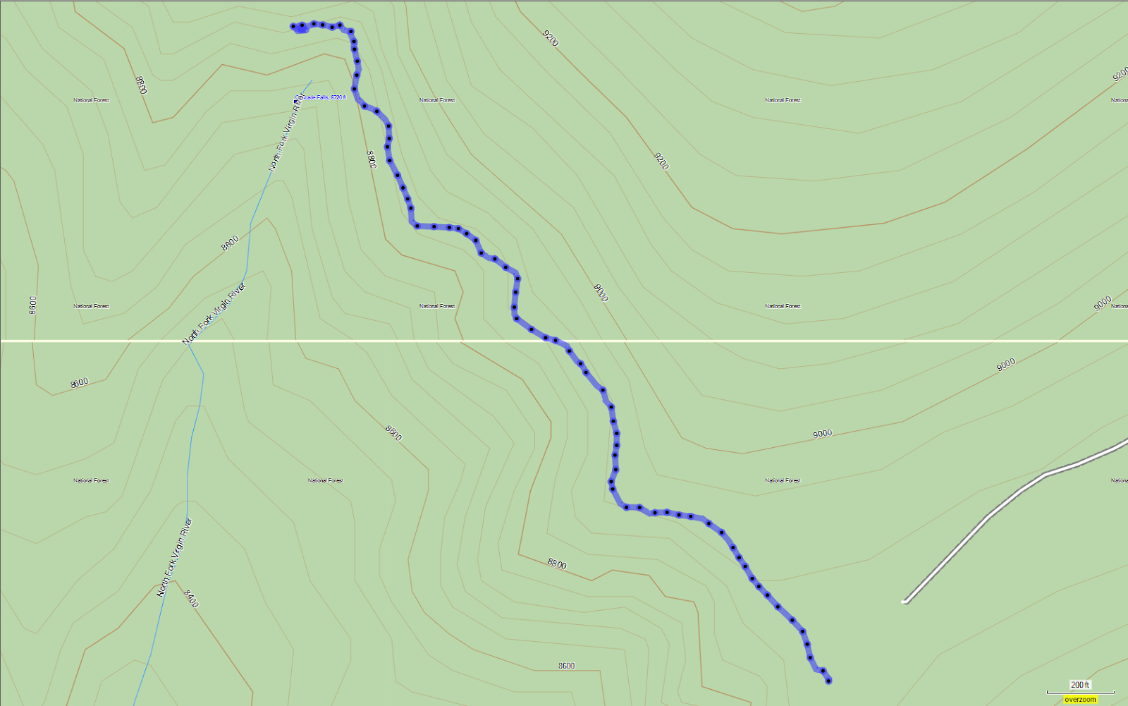
Cascade Falls Trail

The Trail
This easy trail is only 0.6 mile long (one way) with about a 114 foot elevation change. This hike is located on Cedar Mountain, and due to its high elevation, it is only accessible during warmer months.

Topographical Map

Graph of Elevation

Trail in Google Earth

The trailhead is well labeled and easy to find. There are lots of great views of the distant Kolob Terrace and Zion National Park from the trail.


View looking at Kolob Terrace


Not far from the falls, the trail follows some steps down to a bench under a ledge.


Cascade Falls

Cascade Falls originates from Navajo Lake. The water from the lake drains through some sink holes, runs through lava tubs, and comes out at the falls. The fall can flow pretty well at times, but due to a dry year and us arriving at the end of the season, the water flow was quite low while we were present.

Update from 2019: Here are a couple pictures of the falls when there is a lot more water. This year was a high water year, so the falls were much larger.


Falls from the top

Leashed dogs are permitted on this trail, and vault toilets are available at the trailhead.

Directions
This trail is located in Kane County, but it is very near Iron County, Utah. It is roughly 29 miles from Cedar City and falls within the Dixie National Forest area. To get there from I-15, take Exit 59 and then head east on 200 N. Turn right onto Main St., then turn left onto Center St./UT-14. Continue on this road for about 25 miles to Navajo Lake Rd./FR053 and turn right. This is a dirt road. Near its start there is a small information center with some picnic tables. Continue up this dirt road until you come to a road that goes left. Turn up this road. When you reach an open field, there is another split for which you must stay right. Continue to the end of this road to reach the dirt parking lot for the trailhead. GPS Coordinates: N37 29.834 W112 45.094

This trail can also easily be reach from turning onto UT-14 from US-89 and then heading to Navajo Lake Rd./FR053.

September 10, 2018

Davis Creek/Triumph Trail Loop

The Trail
This moderate trail is about 0.9 mile round trip with an elevation change of about 490 feet. We followed the Davis Creek Trail up and came down on the Triumph Trail, so that direction is reflected in the elevation graph below.

Topographical Map

Graph of Elevation

Trail in Google Earth

You can go up to the waterfall either on the Triumph Trail or the Davis Creek Trail. The Davis Creek trail starts just a short distance south up the road from the dirt parking area and is well marked. The Triumph Trail has been moved recently so that it starts at the gate across from the parking area, as explained below.


The trail heads up steeply, but it is short. Please note that if this trail were longer, it would be classified as difficult. Some labeled turn offs can be found along the way up, like the turn off to Pretty Valley and to Hells Hole, both of which you can find more information on here. There is also an unmarked turn off right before the one to Pretty Valley that heads to the Indian Bath Tubs. This short trail is shown in red on the maps above. It used to be labeled, and there used to be ropes here that could be used as hand lines, but this time we went all of that was gone. You can still find nice views of the little falls tumbling into small pools of water if you follow this path, but keep in mind that it is a bit steep and can be slick climbing on the rocks.

Indian Bath Tubs

Continuing further up the canyon on the trail past the Hells Hole turn off and over a bridge, the trail follows the stream for a bit longer before switching back and heading up the opposite side of the canyon from where it started. Soon after this switchback, there is a trail heading west down the canyon, which is where you will return to in order to follow the Triumph Trail down the canyon if you go the same way we came. If you continue the climb up though, you will soon come to a group of rocks jutting up from the slope of the mountain. From these rocks, you will have an excellent view of the waterfall further up the canyon.

View of falls from the rock


You may also notice some very cool looking metamorphic rocks with some pronounced wavy lines running through them in the area.


There are also nice views of the valley from here.


There is a trail that continues closer to the falls just on the other side of these rocks (shown in gray on the maps above), but it trails off in disappointment, leaving hikers with little to no view of the waterfall. Those wishing to continue longer though can continue to climb the Triumph Trail. It heads up to a bench and then continues up along the north side of the canyon above the falls.

If you wish to go down, return to the trail split and head west. About 0.3 mile from the rocky viewpoint, you will come to a dirt road (as marked with blue flag on the topographical map above). Take this dirt road and stay left at all the road intersections until you return to the parking area. (If you start from this end, begin by going around the gate and turn off the main dirt road after it switches southward before it turns to go north again, as show on the topographical map for the Grotto in Hornet Canyon Trail.)

Please note that this is not what we did. We tried following where the trail used to be. It was not as obvious a path as the road, but it was the way we had gone previously. (In fact, at the time of this post, it is still the path shown on the Farmington City website and maps of the area.) Going this way, trail became particularly difficult to follow at its end. It appears to have been washed out in a slide, which is probably why it was re-routed to the dirt road. The trail disappeared at this point in a hill of slippery dirt and gravel.

Washed out portion of original Triumph Trail

If you look at the Google Earth image, you can see the clear path of the dirt road we should have taken. It will be a longer route, but an easier one.

Washout area of original trail

Original trailhead for the Triumph Trail - notice the metal
post with the sign missing

New trailhead for the Triumph Trail

There are no bathrooms at the trailhead. Leashed dogs are permitted on these trails.

Directions
This trail is located in Davis County, Utah in Farmington. To get there from north of Farmington, take exit 325 off of I-15 and turn left onto Park Lane. Next, turn right onto Main Street and continue on this road as it curves around. When you reach State Street, turn left and follow this road as it curves around a bend. Keep going until you reach Woodland Dr., then turn left. At the end of Woodland Dr. you will come to a dirt road called Little Valley Road. Drive up to the reservoir and you will find a dirt parking area. There is also a trail map here. You can walk up the road to the trailhead from here. There are multiple trailheads, so look for the one that is labeled "Davis Creek Trail." Alternatively, you can start at the Triumph Trailhead at the gate across from the parking area.

If you are coming from the south, take exit 222 off of I-15 and continue along 200 West to 200 South. Turn right onto 200 South, and next turn right onto 200 East. From there, turn left onto Woodland Dr. and continue as outlined above. GPS Coordinates: N40 57.961 W111 52.367