October 18, 2011
Dutch Hollow Trails
The Trails
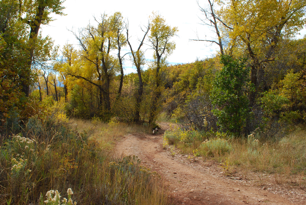
These easy to moderate trails are found in Midway, UT. We hiked along the Overlook, Sage, Aqueduct, and Cottontail Trails. Unfortunately, we lost our GPS data, and therefore are unable to post that information here. However, for maps of the area and descriptions of various sections, go here.
These trails are especially popular for mountain bikers, but they are also commonly used for hiking and horseback riding. They are part of the Wasatch Mountain State Park.
While we do not have the elevation profiles or other information for these trails, we do have some pictures of the area. It is particularly beautiful area during the fall. The Overlook Trail especially offers some nice panoramic views of the valley and surrounding mountains. There are also some wooden benches along the trail that provide convenient places to rest and/or just enjoy the scenery.
Directions
These trails are located in Wasatch County in Midway, Utah. If you are coming from Utah Valley or from anywhere south of Utah Valley, take I-15 to Exit 272 for 800 North in Orem. At the end of 800 North, stay left and follow the signs onto Provo Canyon Road. Continue through the canyon and past the reservoir to 3600 West/Charleston Road. This road will be on your left. Turn onto it and head straight north until you reach Midway. Then turn right onto Main Street. Next, turn left onto River Road. Continue along River Rd. until you come to Dutch Canyon Rd. on the left. The first part of this road is paved, and then it turns into a dirt road. You can park in a paved area and walk to the trail head, or you can drive up the dirt road to another parking area at the trail head.
If you are coming from the Salt Lake area, or somewhere north of that, take I-15 to East I-80. From there, take Exit 146 for US-40 towards Vernal/Heber. Continue for about 13.3 miles, then turn right onto River Rd. After a couple more miles, turn right onto Dutch Canyon Rd. and continue to the trail head.
August 10, 2011
Vermillion Castle Trail
The TrailThis is a moderate 0.8 mile (one way) trail with a 517 foot elevation change. However, although the trail averages moderate, all the climbing for this trail takes place along the switchbacks during the first half, and this section of the trail would probably classify as difficult.
There are a number of interesting rock formations along the trail. A small wind cave is located along the swtichbacks, and as hikers approach the top, there are a number of ridges formed out of conglomerate rock. There are even some wild looking hoodoos formed from the conglomerate rock. Soon after the hoodoos the trail levels out a great deal with only very gentle elevation changes until you reach the end of the trail. Enjoy the interesting white sandstone rocks and the twisted trees as you continue along and finally reach the Vermillion Castle rock formations that mark the trail's end.
On the maps below, a little detour is shown in green that lead to a lookout spot.
There is also a picnic and camping area just before the Vermillion Castle trail head if you turn off for the Noah's Ark trail head. There are nice restrooms here with flush toilets, however, the water at this spot is not potable.
![]() |
| Topographical Map (green=side path to lookout) |
![]() |
| Graph of Elevation |
![]() |
| Trail in Google Earth (green=side path to lookout) |
![]() |
| Vermillion Castle |
![]() |
| View of Noah's Ark with white sandstone rocks in foreground |
![]() |
| Hoodoos |
Directions
This hike is located in Iron County near Cedar City and Parowan. If
you are approaching Parowan from the north, take exit 78 off of I-15 and turn left onto Main Street. Continue to UT-143/Canyon Rd. and turn right. About 3.6 miles down this road, turn left onto Yankee Meadow Road/Bowery Creek Road/1st Left Hand Road. The trail head is a little over two miles up this road on the left side.
If you are coming from the south, take exit 75 off of I-15 and turn right onto 200 South. Turn right onto UT-143/Canyon Rd. and continue about 3.1 miles until you reach Yankee Meadow Road/Bowery Creek Road/1st Left Hand Road Continue as explained above.
August 05, 2011
God's Rock Trail
This is an easy 1 mile (one way) trail with an elevation change of only about 85 ft. The trail starts from Loop E at the Blackhawk Campground. Soon after the trail head you pass through a gate (marked by green flag on the map below - don't forget to close it behind you). As you continue along, the trees gradually open up revealing views of the surrounding mountains. The trail ends at the top of a hill with nice panoramic views. We didn't get all the way to the top of the hill, so the information given about trail length and elevation change is only valid for the portion of the trail we traveled. The rest of the trail is shown in green as a rough estimation of the rest of the trail on the maps below.
The trail was a little difficult to follow in some places since it was rather overgrown in areas. A few trails seemed to break off from it heading west that are also a bit difficult to follow.
This trail is open to horses. The blue flag marks a watering trough in the middle of Soap Flat.
![]() |
| Topographical Map (green=estimation of continuation of trail) |
![]() |
| Graph of Elevation |
![]() |
| Trail in Google Maps (green=estimation of continuation of trail) |
![]() |
| Mount Nebo |
Directions
This trail is found along the Nebo Loop in Utah County. If you are coming from the north, take exit 250 for Payson off of I-15. Turn left onto 3200 West, which turns into Main Street. Follow Main Street to 800 South and turn left. Take the first right onto South Canyon Road. When the road ends, turn right again onto Nebo Loop Rd. Continue on this road up the canyon for about 13 or 14 miles until you see signs for Blackhawk. Turn left onto Blackhawk Campground Rd. and follow the signs to Loop E. If you don't have a campsite in the area, there is a parking lot at the front of the loop with a $6.00 fee to park there for the day. The trail starts on the east side of the loop at about N39 53.368 W111 37.464.
August 03, 2011
Lake Angela by way of the Pacific Crest Trail
This trail is an easy 3.2 mile (one way) stretch of
![]() |
| Lake Angela |
the Pacific Crest Trail with a 276 foot elevation change. The trail is lined with tall evergreen trees, splashed with colorful wildflowers, and scattered with smooth granite boulders. It sports fantastic views of the surrounding peaks and of Donner Lake. The first part of the trail is very shady and there are several muddy ponds in which catfish can be seen. Parts of the trail may be muddy or covered with snow. The ponds and a marsh area make ideal mosquito breeding grounds, so wearing bug repellent is a good idea.
As the trail continues, it becomes more open and rocky. The trail drops a little before rising again. After reaching the summit and starting down, Donner Pass Road and the train tracks are visible to the south. If you continue along the trail, you will eventually reach Donner Pass Road. To get to Lake Angela, we turned off the trail soon after we reached the summit. We heard rumors of a trail that turns off to the lake from the Pacific Crest Trail before this point, but we couldn't find it. Instead, after the first switchback or two on the way down, we headed over the ridge and toward the power lines immediately west of the trail (turn off point marked on the map with a green dot: N39 19.425 W120 19.311). After crossing over the ridge, we could see the lake below. We made our way through some brush and followed what appeared to be odd pieces of various disconnected trails down to the lake. Angela Lake itself is beautifully clear and blue.
Azalea Lake and Flora Lake are not visible from the Pacific Crest Trail, but probably would not be hard to find with a map and/or GPS. There is supposed to be a turn off from the Pacific Crest Trail at N39 20.24469 W120 19.85254 (marked with a red triangle in the map below) for a trail that goes past all the lakes, and this route is also shorter than following the Pacific Crest Trail. However, it is not obvious or easy to find, and we missed that trail as well.
![]() |
| Topographical Map |
![]() |
| Graph of Elevation |
![]() |
| Trail in Google Maps |
![]() |
| One of the Mud Ponds |
![]() |
| View of Donner Lake from the Pacific Crest Trail |
![]() |
| Lake Angela |
DirectionsFrom I-80, take exit 176 for Castle Peak/Boreal Ridge Rd. (about a 45 minute drive from Reno). After exiting, turn south. At Bunny Hill Dr., turn left and continue to the parking lot at the end of the road. The trail head is well marked with a plaque detailing the Pacific Crest Trail and some other trails in the area.
July 26, 2011
Hidden Valley Trail
The TrailThe Hidden Valley Trail is a moderate 2.5 mile (one way) trail with an elevation change of 2046 feet. The beginning of this trail follows the Indian Trail heading northwest, so follow the signs for this trail as you start out from the trail head. The Hidden Valley Trail breaks off from it about .6 miles up from the start of the Indian Trail and turns southeast from there. The turn off occurs at a rocky area and is marked by a red arrow that says "Hidden Valley" painted on one of the rocks. The trail also immediately picks up its rate of ascent at this point. The climb remains mostly steady to the end of the trail with occasional short sections that are more level.
On the topographical map below, the red flag marks a slight turn off from the main trail that leads to a rocky view point. The blue flag marks a fire pit.
Most of the trail is fairly sun baked as it winds along the exposed face of the mountain while giving hikers nice panoramic views of the valley below. However, a little ways after the rocky view point, the terrain changes and the vegetation becomes more lush. The air becomes noticeably cooler and hikers will cross through a number a mini meadows full of wildflowers before reaching the view point at the end of the trail. The trail concludes with a large rock cairn and a view of Taylor Canyon and the mountains across the way.
![]() |
| Topographical Map |
![]() |
| Graph of Elevation |
![]() |
| Trail in Google Maps |
![]() |
| Rock Cairn and View at the Trail's End |
![]() |
| View of the Valley |
![]() |
| Turn off from Indian Trail onto Hidden Valley Trail |
![]() |
| Rock Painted with a red arrow to mark the turn off |
![]() |
| Near the trail's end are a number of little meadows |
Directions
This trail is located in Weber County, Utah. If you are trying to reach the trail head from south of Odgen, take I-15 to Exit 341 for 31st Street in Odgen. Turn right onto 31st Street, continue to Washington Blvd., turn left, and then take the first right onto 30th Street. Continue straight to 1200 E/Harrison Blvd. and turn left. Take a right at 22nd Street and continue up this road until you reach the parking lot at its end. The Indian Trail starts from here and is marked by an informative plaque under a little roofed structure.
If you are coming to the trail from north of Ogden, you can either take Hwy 89 to 12th Street and from there turn right onto Harrison Blvd. and continue to 22nd Street, or you can take I-15 to Exit 343 for 21st Street in Odgen. Turn left to head east along 21st Street to Wall Ave. Turn left on Wall Ave., right onto 20th, and then right onto Harrison Blvd. From there you can turn left onto 22nd Street and continue to the parking lot as explained above.
July 05, 2011
Stewart Falls

The Trail
This easy trail is about 1.8 miles long (one way) with an elevation change of 384 ft. The trail starts off with a mild climb before leveling off some and then descending to the falls. The trail ends at the base of Stewart Falls, a two tiered waterfall that drops over 200 ft.
This is a very popular trail among all age groups, and it is easy to understand why. It is fairly short, easy to travel, quite scenic, and ends with a fantastic waterfall. There is also a fairly good amount of shade along the trail during most of day. Don't be surprised to find a lot of hikers along this trail when you go, especially if you go on a weekend or holiday. If you go early enough in the year, you will also probably find some snow along the trail and/or at the waterfall.
Leashed dogs are permitted on this trail. Water and outhouses are available at the trail head. For more information on this area, please see Alpine Loop.
![]() |
| Topographical Map |
![]() |
| Graph of Elevation |
![]() |
| Trail in Google Earth |
If you cross the river at the end of this trail, you can also find a short rough trail (not shown on maps) that goes up to the smaller waterfall shown in the picture below. This little waterfall is from the stream of water seen to the left of Stewart Falls in the picture above.
Also, be aware that there is a good deal of stinging nettle along this trail. It will make your skin itch if you come into contact with it. Stinging Nettle has serrated edges on its leaves, hairy stems, and bluish flowers. Stay away from it, and/or wear long pants and closed shoes to avoid contact with it.
![]() |
| Stinging Nettle |
![]() |
| Field of Stinging Nettle Along the Trail |
![]() |
| Stinging Nettle Next to the Trail |
![]() |
| Stewart Falls |
This trail is also great to snowshoe during the winter
![]() |
| Stewart Falls in Winter |
Directions
This trail is located in Utah County along the Alpine Loop. To get to the trail head, take exit 272 in Orem off of I-15. Head east along 800 North. Stay left when the road ends and splits to head up Provo Canyon. Continue up the canyon to the Alpine Scenic Hwy. Turn left at this road and continue up it past Sundance and Aspen Grove. You will reach a booth where you will have to pay $6.00 to continue. Take the first parking lot on the left right after this point. There are two major trail heads that depart from the lot. The first goes to the top of Timpanogos. The Stewart Falls trail head is on the far side of the parking lot across from the amphitheater.