2012 Update: We have been informed that this canyon and surrounding area have burned down in a fire this summer. We don't know if there is anything left of this trail, or if there are any plans to re-establish the trail in the future. If anyone has further information about the state or future plans for this trail, please let us know in the comments. Thanks!
 This moderate trail in Oak Creek Canyon is 2.2 miles long (one way) with a 1823 foot elevation change. It maintains a fairly consistent and steady elevation gain throughout the trail. The trail head is well marked, and most of the trail is easy to follow. However, some places are a bit overgrown, and by somewhere in the last quarter to half mile of the trail, the dirt path mostly disappears and hikers must follow the rock cairns for a little ways. There is not much shade along the trail.
The trail was created in honor of Spencer Koyle, a firefighter who lost his life while battling a wildfire that swept through the area. Evidence of the fire is apparent along the trail as it winds past blackened trees. A number of educational plaques are placed along the trail detailing information about wildfires and fighting wildfires. The trail ends with a nice view behind a little monument made up of some sculpted firefighting tools.
 |
| Topographical Map |
 |
| Graph of Elevation |
 |
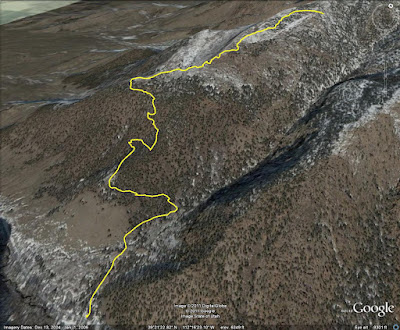
| Trail in Google Earth |
 |
| The monument at the trail's end |
 |
| View looking more toward the west at the end of the trail |
Directions
This trail is located in Oak Creek Canyon, which is near Delta in Millard County, Utah. To get there from I-15, take exit 225 in Nephi and head west on 100 N/UT-132. Continue on this road to Leamington, then turn left onto 300 E/UT-125. Take this road to Oak City and then turn left onto Center St., which will be right after the church on the left. Center Street will turn some to the right and become 200 E, and then in continues on and becomes Oak Creek Canyon Road. The trail head will be up the canyon a short ways on the left. There is a small dirt parking lot and a large plaque at the trail head.
 |
| Claret Cup Cacti: There is a lot of this along the trail |


No comments:
Post a Comment