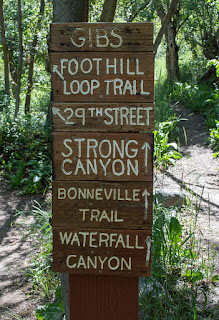
This easy loop trail is 3.1 miles long (round-trip) with about a 323 foot elevation change. We started this loop from the 36th Street Trailhead, but you can also start it from the trailhead at the end of 29th Street. The elevation graph reflects starting from 36th Street though.
 |
| Topographical Map |
 |
| Graph of Elevation |
 |
| Trail in Google Earth |
We started by heading up the side of the trail. There are a number of splits along this first part of the trail, but it is still easy to stay on the right trail since it is pretty clearly marked.We soon arrived at a bench situated on a bridge that crosses Strong Creek. Just before that point is a split in the trail. If you continue heading east instead of staying on Gib's Loop, you can access the Bonneville Shoreline Trail and Waterfall Canyon.
 |
| Strong Creek at the bridge |
The trail moves in and out of shady areas. The east side of the trail is situated right above the golf course for much of the way.
 |
| Wild Flax |
If you start from 36th Street and go the way we went, you will come to another trailhead to the north of the park past a condominium. To continue along Gib's Loop, you must walk to the end of the parking area and then turn down 29th Street. The distance along this section of trail between 36th Street and 29th Street is 1.4 miles. Keep going until you reach Taylor Avenue, then turn south and walk along this street.
After you reach the first playground area, you can turn into the parking lot next to it and pick up the trail running back toward the fence (shown in red on the maps above). Or, you can continue on to 33rd Street, where a sign clearly marks where the dirt trail picks up again. The distance from this sign to 36th Street is 0.8 mile.
Leashed dogs are permitted on this trail; just be sure to clean up after your dog.
Directions
This hike is located in Ogden, which is is Weber County, Utah. To get there from the south, take I-15 to Riverdale Road, exit 339. Turn right onto Riverdale Road and continue to 36th Street. Turn right onto 36th and continue until the road starts to turn into Skyline Dr. The parking area will be on your left.
If you are coming from the north, take exit 341 for 31st Street. Head east to Wall Avenue and turn right. Continue to 36th Street and turn left. Keep going as explained above to the trail head.
Alternatively, you can start this trail from the end of 29th Street.


No comments:
Post a Comment