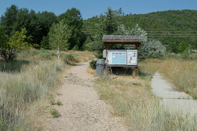
The Trail
This easy trail is about a mile long (one-way) with about a 138 foot elevation change. It takes hikers from the visitor's center in Midvale to Huber Grove, the historic homestead site of the Huber family.
 |
| Topographical Map - Blue trail markers indicate connection points to Epperson Trail |
 |
| Graph of Elevation |
 |
| Trail in Google Earth |
This trail basically follows Snake Creek Rd. the whole way, crossing the road just a little ways before the grove.
 |
| Trailhead |
Along with views of the road, the trail also offers the neighboring golf course and surrounding mountains for its scenery.
 |
| Trail in mid-May |
Huber Grove is a pleasant area with several picnic tables, old apple orchards, the historic house, and the stone creamery.In the spring, the trees are covered in beautiful blossoms.
 |
| Huber Grove with the historic house |
 |
| The Creamery |
 |
| Huber Grove orchard in the spring |
Snake Creek runs through the property with a little bridge crossing it that leads to a dirt parking area.
Visitor's can also drive to Huber Grove. There is a fee though to park there. Bathrooms are available both at the visitor's center and at Huber Grove.
Directions
This trail are located in Wasatch County in Midway, Utah. If you are coming from Utah Valley or from anywhere south of Utah Valley, take I-15 to Exit 272 for 800 North in Orem. At the end of 800 North, stay left and follow the signs onto Provo Canyon Road. Continue through the canyon and past the reservoir to 3600 West/Charleston Road. This road will be on your left. Turn onto it and head straight north until you reach Midway. Then turn right onto Main Street. Next, turn left onto River Road. Continue along River Rd. until you come 1050 North on the left. Continue on this road to Homestead Dr./State Route 222, and turn right. After crossing Warm Springs Rd, this road changes to Snake Creek Rd., and you will come to the visitor's center on the right very soon thereafter.
If you are coming from the Salt Lake area, or somewhere north of that, take I-15 to East I-80. From there, take Exit 146 for US-40 towards Vernal/Heber. Continue for about 13.3 miles, then turn right onto River Rd. After a couple more miles, turn right onto 1050 North. Continue as outlined above. GPS Coordinates: N40 31.975 W111 29.429


No comments:
Post a Comment