July 26, 2011

Hidden Valley Trail

The Trail

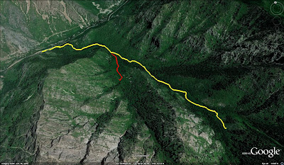
The Hidden Valley Trail is a moderate 2.5 mile (one way) trail with an elevation change of 2046 feet. The beginning of this trail follows the Indian Trail heading northwest, so follow the signs for this trail as you start out from the trail head. The Hidden Valley Trail breaks off from it about .6 miles up from the start of the Indian Trail and turns southeast from there. The turn off occurs at a rocky area and is marked by a red arrow that says "Hidden Valley" painted on one of the rocks. The trail also immediately picks up its rate of ascent at this point. The climb remains mostly steady to the end of the trail with occasional short sections that are more level.

On the topographical map below, the red flag marks a slight turn off from the main trail that leads to a rocky view point. The blue flag marks a fire pit.

Most of the trail is fairly sun baked as it winds along the exposed face of the mountain while giving hikers nice panoramic views of the valley below. However, a little ways after the rocky view point, the terrain changes and the vegetation becomes more lush. The air becomes noticeably cooler and hikers will cross through a number a mini meadows full of wildflowers before reaching the view point at the end of the trail. The trail concludes with a large rock cairn and a view of Taylor Canyon and the mountains across the way.


Topographical Map

Graph of Elevation

Trail in Google Maps

Rock Cairn and View at the Trail's End

View of the Valley

Turn off from Indian Trail onto Hidden Valley Trail

Rock Painted with a red arrow to mark the turn off

Near the trail's end are a number of little meadows


Directions

This trail is located in Weber County, Utah. If you are trying to reach the trail head from south of Odgen, take I-15 to Exit 341 for 31st Street in Odgen. Turn right onto 31st Street, continue to Washington Blvd., turn left, and then take the first right onto 30th Street. Continue straight to 1200 E/Harrison Blvd. and turn left. Take a right at 22nd Street and continue up this road until you reach the parking lot at its end. The Indian Trail starts from here and is marked by an informative plaque under a little roofed structure.

If you are coming to the trail from north of Ogden, you can either take Hwy 89 to 12th Street and from there turn right onto Harrison Blvd. and continue to 22nd Street, or you can take I-15 to Exit 343 for 21st Street in Odgen. Turn left to head east along 21st Street to Wall Ave. Turn left on Wall Ave., right onto 20th, and then right onto Harrison Blvd. From there you can turn left onto 22nd Street and continue to the parking lot as explained above.

July 05, 2011

Stewart Falls

The Trail

This easy trail is about 1.8 miles long (one way) with an elevation change of 384 ft. The trail starts off with a mild climb before leveling off some and then descending to the falls. The trail ends at the base of Stewart Falls, a two tiered waterfall that drops over 200 ft.

This is a very popular trail among all age groups, and it is easy to understand why. It is fairly short, easy to travel, quite scenic, and ends with a fantastic waterfall. There is also a fairly good amount of shade along the trail during most of day. Don't be surprised to find a lot of hikers along this trail when you go, especially if you go on a weekend or holiday. If you go early enough in the year, you will also probably find some snow along the trail and/or at the waterfall.

Leashed dogs are permitted on this trail. Water and outhouses are available at the trail head. For more information on this area, please see Alpine Loop.

Topographical Map

Graph of Elevation

Trail in Google Earth


If you cross the river at the end of this trail, you can also find a short rough trail (not shown on maps) that goes up to the smaller waterfall shown in the picture below. This little waterfall is from the stream of water seen to the left of Stewart Falls in the picture above.


Also, be aware that there is a good deal of stinging nettle along this trail. It will make your skin itch if you come into contact with it. Stinging Nettle has serrated edges on its leaves, hairy stems, and bluish flowers. Stay away from it, and/or wear long pants and closed shoes to avoid contact with it.

Stinging Nettle

Field of Stinging Nettle Along the Trail


Stinging Nettle Next to the Trail

Stewart Falls

This trail is also great to snowshoe during the winter

Stewart Falls in Winter

Directions

This trail is located in Utah County along the Alpine Loop. To get to the trail head, take exit 272 in Orem off of I-15. Head east along 800 North. Stay left when the road ends and splits to head up Provo Canyon. Continue up the canyon to the Alpine Scenic Hwy. Turn left at this road and continue up it past Sundance and Aspen Grove. You will reach a booth where you will have to pay $6.00 to continue. Take the first parking lot on the left right after this point. There are two major trail heads that depart from the lot. The first goes to the top of Timpanogos. The Stewart Falls trail head is on the far side of the parking lot across from the amphitheater.


June 17, 2011

Devil's Den Legacy Trail

The Trail

2012 Update: We have been informed that this canyon and surrounding area have burned down in a fire this summer. We don't know if there is anything left of this trail, or if there are any plans to re-establish the trail in the future. If anyone has further information about the state or future plans for this trail, please let us know in the comments. Thanks!


This moderate trail in Oak Creek Canyon is 2.2 miles long (one way) with a 1823 foot elevation change. It maintains a fairly consistent and steady elevation gain throughout the trail. The trail head is well marked, and most of the trail is easy to follow. However, some places are a bit overgrown, and by somewhere in the last quarter to half mile of the trail, the dirt path mostly disappears and hikers must follow the rock cairns for a little ways. There is not much shade along the trail.

The trail was created in honor of Spencer Koyle, a firefighter who lost his life while battling a wildfire that swept through the area. Evidence of the fire is apparent along the trail as it winds past blackened trees. A number of educational plaques are placed along the trail detailing information about wildfires and fighting wildfires. The trail ends with a nice view behind a little monument made up of some sculpted firefighting tools.

Topographical Map

Graph of Elevation

Trail in Google Earth


The monument at the trail's end

View looking more toward the west at the
end of the trail

Directions

This trail is located in Oak Creek Canyon, which is near Delta in Millard County, Utah. To get there from I-15, take exit 225 in Nephi and head west on 100 N/UT-132. Continue on this road to Leamington, then turn left onto 300 E/UT-125. Take this road to Oak City and then turn left onto Center St., which will be right after the church on the left. Center Street will turn some to the right and become 200 E, and then in continues on and becomes Oak Creek Canyon Road. The trail head will be up the canyon a short ways on the left. There is a small dirt parking lot and a large plaque at the trail head.

Claret Cup Cacti: There is a lot of this along the trail

October 16, 2010

Coldwater Creek Trail

The Trail

This moderate 1.8 mile (one way) trail in Ogden Canyon has a 1416 foot elevation change. Overall, the trail holds a fairly steady climb as it heads up the mountain. Coldwater Creek Trail shares a trail head with the more popular Indian Trail. The trail is not hard to find or follow. Just stay on the main trail for about the first 0.8 miles. You will cross two bridges, and right before the third bridge, another trail splits off to the left. For this trail, stay to the left at this junction. Otherwise, you will be continuing on the Indian Trail.

The Coldwater Creek Trail continues up the canyon a ways. There is a good deal of shade since there are a lot of trees along the path, and it can be very pretty in the fall when the leaves are changing. As you near the end of the trail, it seems to gradually become more overgrown until it fades off and disappears.

Topographical Map (Coldwater Creek = Blue; Indian Trail = Red)

Graph of Elevation
Trail in Google Earth (Coldwater Creek = Yellow; Indian Trail = Red)


Last  good view point near end of the trail


Directions

This trail is located in Ogden Canyon, which is in Weber County, Utah. If you are coming from the south, go up I-15 to exit 341 for Ogden's 31st Street. After exiting the freeway, turn right to head east. Turn left when you reach Washington Blvd. Then continue for a ways until you reach 1200 South/12th Street. Turn right and continue straight along 12th Street for about 3.6 miles heading up the canyon. A sign for the Indian Trail will indicate the turn-off to the right onto a dirt road.This will lead you to a dirt parking lot for the trail head.

If you are coming from the north, take exit 349 off of I-15. Turn left to head east along 2700 North, then turn right onto US-89 heading toward Ogden. Continue along this road until you reach 1200 South/12th Street. Turn left, then continue to the trail head as explained above.

September 08, 2010

White Pine Lake Trail

White Pine Lake
The Trail

This is a moderate 3.8 mile (one way) trail with 763 foot elevation change (but keep in mind this trail goes up, down, and a little up again). The trail starts at Tony Grove heading north. It progresses at a gradual climb until it goes around the mountains and then descends to the lake on the opposite side. The lake does not become visible until you reach the top of the very last little hill, but as you approach the lake, the trail does cross a couple small streams. Once at the lake, the trail continues for a ways following the shoreline, allowing for many good views of this beautiful area.

This trail is open to horses, dogs, and backpackers. There are backpacking campsites near White Pine Lake, and an outhouse is available there too. There are also restrooms and water available at Tony Grove.

Tony Grove Lake

This trail is well labeled and easy to follow. Tony Grove also marks the trail head for Naomi Peak (a 3.3 mile one way trail). The red flags on the topographical map below mark turn offs along the While Pine Lake Trail for Naomi Peak. There is also a short nature trail at Tony Grove that circles the Tony Grove Lake.
Topographical Map

Trail in Google Earth

Graph of Elevation

White Pine Lake with Mount Magog in background

View of Mount Magog from the south side

Don't be surprised to see sheep or
cows along the trail; ranchers use
this area for grazing their animals

Directions

This trail is located up Logan Canyon. To get there from the Wasatch Front, follow Hwy 89 north to Logan, Utah. Once in Logan, turn east on 400 North to continue on Hwy 89. Continue for about 21.7 miles until you reach Tony Grove Road, which will be on the left. Head up this road until you reach the parking lot and lake at the end. The trail head is at the end of the lot.

August 24, 2010

Blackhawk Trail Mix

View of Loafer Mountain along trail
 The Trail

This trail is actually the conglomeration of different sections of a few trails. Two options are shown below. The first option comes out to be an easy to moderate 8.5 mile trail with an approximate 620 foot elevation change. Also shown on the maps below (in red) is an extra loop that is 1.4 miles long, or about .6 miles longer than doing just the first option, and take travelers through a very pleasant aspen grove.

The trails in this area are high up along the Nebo Loop and offer a number of beautiful views. This area is also covered with wildflowers in the summer. The trail leads through a variety of terrain from open meadows to aspen groves and pine forests.

This trail is open to hikers, horseback riders, bicyclists, and dogs. Some sections are also open to motor bikes, so watch out for them.

There are many different trails lacing through this area and intersecting with one another, so it is probably a good idea to bring a map with you if you are not familiar with the area. We started this trail from Blackhawk Loop E Campground heading east along the Blackhawk Trail. On the map below, trail intersections are marked with colored flags:

001:  If you turn west here, you will end up at Dipping Corral Spring
002:  Trail split: Turn west to head along the Rock Springs Trail (the sign here indicates that by going this way you will reach the ranger station). You will go up a hill and come to a dry camp and then cross the road. If you go north at the fork, the trail continues to the north origin of the Blackhawk Trail.
003:  The livestock corral. The trail splits just after it passes the corral. Go right to take the longer loop, or stay left for the shorter route.
004:  The trails meet up again. Head south east to turn back onto the Jones Ranch Trail and reach Dipping Corral Spring.
Dipping Corral Spring:  There is a missile shaped trough here. This is a good place to let your livestock drink. At this meadow you should meet up with the Blackhawk Loop Trail.
005:  Trail split. The trail dips down into a little open area here, and a couple signs label the four or five trails that intersect here.. Take a sharp left to head east and stay on the Blackhawk Loop Trail.
Water Trough:  This marks the beginning and the end of the trail for us. If you are riding, it is another good place to let your horses drink

Topographical Map of Entire Trail

Detail of the Lower Section of the Trail
 
Detail of the Upper Section of the Trail

Also note that a little ways before you reach Dipping Corral Spring, the trail crosses the road. The trail becomes a bit hard to follow right before you reach the road, and it can sometimes be a little difficult to find the pick up for the trail on the other side.

The land in this area is used by ranchers for their cattle to graze on during the summer. Make sure you close all gates along the trail so that cattle are contained to their grazing areas.

Trail in Google Earth

Graph of Trail Elevation (without longer loop)

Graph of Elevation for just the extra loop portion of the trail
 
Loafer Mountain during a thunderstorm

View heading back around to Blackhawk during the last segment of the trail


Directions

This trail is found along the Nebo Loop in Utah County. If you are coming from the north, take exit 250 for Payson off of I-15. Turn left onto 3200 West, which turns into Main Street. Follow Main Street to 800 South and turn left. Take the first right onto South Canyon Road. When the road ends, turn right again onto Nebo Loop Rd. Continue on this road up the canyon for about 13 or 14 miles until you see signs for Blackhawk. Turn left onto Blackhawk Campground Rd. and follow the signs to Loop E. This is where we started the trail from, but you could find where the trail intersects with the road at other places and start there as well. If you start from the campground, there are some parking areas for those who are not at a campsite, but be aware that there is a parking fee of $6.00.

If you are coming from the south, it is better to take exit 248 off of I-15, turn right onto 800 South, and continue straight until you reach South Canyon Road.  

Here is  the meadow where we started the trail.
Loafer mountain is in the background and the water
trough is a little to the right in the picture.