The Trail
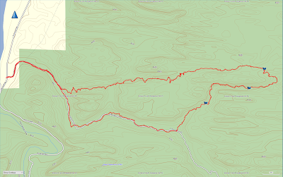
This moderate technical route requires some class three
climbing/rock scrambling and involves 2-3 rappels. The canyoneering route is about a
4.5 mile loop with about a 727 ft. change in elevation.
 |
| Topographical Map |
 |
| Graph of Elevation |
 |
| Trail in Google Earth |
This trail starts up Pritchett Canyon ATV Road (requiring a fee to cross the private ground in front of this road). After a half mile, adventurers must turn left up the narrow side canyon. Head up this canyon, watching out for poison ivy as you go. The canyon appears to dead-end from a distance, but as you get closer it becomes apparent that you can climb up this gully and continue.
 |
| Trail Entrance - entrance fee paid here to cross private land |
 |
| Pritchett Canyon ATV Road - head up this for about a half mile |
 |
| Turn off for Rock of Ages Route into side canyon |
 |
| Looking back down on the climb up the narrow gully |
There
is a fairly clear trail that continues here. As always in this sort of
terrain, be sure to stay on the trail and/or rocks to avoid destroying cyrptobiotic soil along the way. Look back along the way to see this jug handle arch.
Walking up a ways further will bring adventurers to another gully to climb up.
 |
| Another spot to climb up |
As
the terrain opens up more, you will come upon the first spot to rappel
about two miles into the trail. You can see the spot in the first
picture below where a group is waiting below to descend. Right behind
the rappel spot sits Pool Arch. There is webbing on a tree here set up for the rappel, but you could also use one of the other trees nearby (as we did since a very large group was using the first tree).
 |
| Coming up to the first rappel |
 |
| Pool Arch |
Alternatively, the first rappel can be avoided by keeping right to climb down a gully to pool arch as explained here. In fact, using this gully to go up and down to retrieve ropes is recommended in order to avoid rope grooves.
If
you do choose the route going down the rappel, it is about a 130 ft/40
meter drop. (That being said, I have seen other places saying it is
closer to 160 ft., but according to our GPS it is much closer to the
places that have said 130 ft.) After the descent, make your way through
the narrow V opening in the rocks under the arch and into the pool of water. Wade or
swim off to the left to continue the route.
 |
| First Rappel |
 |
| Head through the V opening into the pool of water |
As you come out of the pool, continue east for a short distance before turning south into the canyon that will then loop back in a westward direction.
 |
| Looking east after the pool. Don't continue on in this direction; turn south. |
The canyon narrows significantly and leads through some tight spots requiring a bit of maneuvering to comfortably pass.
 |
| Bridging across this pool works best |
 |
| We found it easiest here to not use the hanging strap but to sit on the second knob and slide over to the foothold on the other side. Climb down and wade through the water. |
After
0.4 mile from the first rappel, you will reach the second rappel point,
a drop of about 50 ft/15 meters. Anchors are set up in the middle of this for rappelling. From this point, the route heads
through a beautiful, more open, high walled canyon area.
 |
| Flowering Prickly Pear |
In
another 0.4 mile from the second rappel, you will arrive at the final
rappel point. There are multiple anchor options for this rappel, the
higher ones requiring a bit more rope than the lower. The lower anchor
involves climbing down a bit to find off to the right side. This rappel
down to an alcove is about 100 ft/30 meters, but plan on some extra rope
for the higher point.
 |
| Final rappel point |
From here, simply continue following the path out of the canyon and back to Pritchett Canyon, then walk down the ATV road back to the trailhead.
 |
| Looking back into canyon where route exits |
 |
| Heading back down Pritchett Canyon |
Directions
This trail is located near Moab, Utah in Grand County. To get there from US-191, turn and onto Kane Creek Blvd., located on the south end of Moab, and head west. Continue for 3.8 miles on this road until you come to the trailhead for Pritchett Canyon on your left. This is located shortly before the road turns to dirt. There is parking here, and more parking about 0.1 mile up the road.
Alternatively, if you are
already coming from the north side of Moab, turn off onto 500 West, and
then turn right onto Kane Creek Blvd. and continue as explained above.
GPS Coordinates: N38° 32.112' W109° 35.977'


No comments:
Post a Comment