May 10, 2012

Little Ruin Canyon Trail

Stronghold House
The Trail


This easy loop trail is 1.5 miles long (round trip) with an optional turnout to Tower Point that adds approximately an extra half mile to the trail. Most of the trail is fairly flat, but there is a steeper area at the end of the loop into the canyon and then back out.

The trail passes a number of Indian ruins along the canyon edge built around 1230 to 1275 A.D. constructed in various shapes and sizes. While there are various theories on their uses, the real purpose of these buildings is unknown. To view a trail map and to read more about the specific ruins along the trail, see this PDF of the trail guide. You can also pick up a trail guide at the visitor's center.


Twin Towers, Rim Rock House, and Eroded Boulder House

Eroded Boulder House

Twin Towers
 

Hovenweep Castle
While viewing the archeological sites, it is important to stay only on designated trails. Stay off of and do not touch the ruins. Do not bring food or leave trash near the ruins as this attracts burrowing rodents that further unstabilize the fragile ruins. Pets are allowed on this trail if they are kept on a leash no longer than 6 feet long.


Hovenweep Castle from across canyon

Looking up at Stronghold House from bottom of canyon

Further along the road past the visitor's center, you can find additional ruins of interest. Contact the park for further information. You can find a map of these areas here.

Square Tower
Directions

This trail is located at Hovenweep National Monument along the Utah Colorado border. If you are coming from the west, from US-191, turn onto US-262/Hovenweep Rd. Continue to Reservation Rd., then turn right. Turn left onto C R 413. Hovenweep will be on the right. The trail starts at the Visitor's Center.

If you are coming from the east, from US-491 N/N turn onto County Rd. CC. Next, turn left onto Co Rd. 10 and continue until you reach Hovenweep on your left.


Point Lookout Trail

The Trail

This moderate trail is about 1.15 miles long (one way) with and elevation change of 500 feet. The first part of the trail is made up of a series of switchbacks through pinyon-juniper forest that climb to the top of the narrow mesa before the trail flattens out. Pets are not allowed on this trail.

Topographical Map

Graph of Elevation

Trail in Google Earth

From the top of the mesa, hikers are rewarded with fantastic views of the surroundingMontezuma and Mancos Valleys as well as the north rim of Mesa Verde. You can also see the park entrance and watch cards winding their way up the road into the park.


View of Ute Sleeping Mountain
Trail heading up switchbacks


Directions

This trail is located in Colorado in Mesa Verde National Park. The park is located along US-160. After paying required fees and entering the park, continue to the Morefield Campground. Turn right onto campground road and continue along this road to the parking lot for the amphitheater at the end. The trail starts at the north end of this parking lot.

Knife Edge Trail

The Trail

This easy trail is only 1 mile long (one way) with just a 78 foot elevation change. This trail follows part of what once was the narrow Knife Edge Road, which was built in 1914 as the main access to the park. When the Morefield-Prater Tunnel was built in 1957, this section of the road was no longer used. The trail overlooks the Montezuma Valley, and is said to be a great place to watch the sunset. Pets are not permitted on this trail.

Topographical Map

Graph of Elevation

Trail in Google Earth

View of Mountains and Valley

Looking up at Point Lookout


Looking out from point at end of the trail

Directions

This trail is located in Colorado in Mesa Verde National Park. The park is located along US-160. After paying required fees and entering the park, continue to the Morefield Campground. Turn right onto campground road and continue along this road until reaching the trail head on the left.

May 09, 2012

Petroglyph Point Trail

The Trail

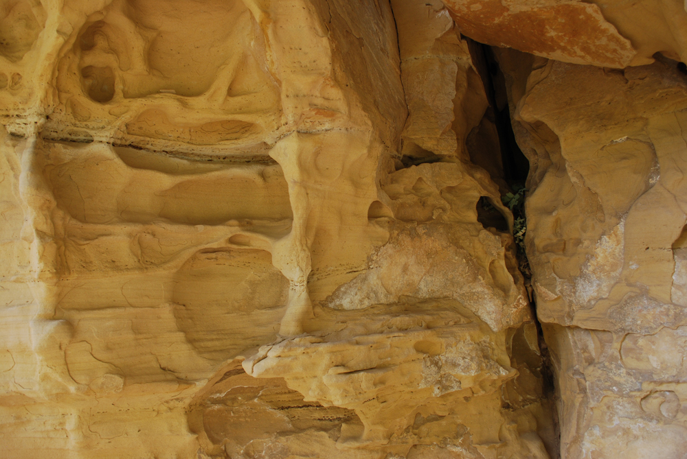
This moderate trail is an approximately 2.8 mile long loop with a 187 foot elevation change (however, keep in mind that this trail does go up and down a fair amount). The trail weaves through rock crevices, up and down narrow stairways, and under sandstone overhangs. Hikers pass a number of interesting rock formations, some cliff house ruins, and other objects of interest before reaching the petroglyphs themselves. It is definitely a beautiful and interesting trail that is well worth the hiking effort!

Topographical Map

Graph of Elevation

Trail in Google Earth

The trail starts from nearby the Chapin Mesa Museum. Walk along the asphalt path following the signs toward the Spruce Tree House (which is also worth looking at). The the Petroglyph Point and Spruce Canyon Trails start near the Spruce Tree House exit sign. These two trails soon separate; follow the signs to stay left on the Petroglyph Point trail. If you want, you can buy a trail guide, which gives additional information about plants, the ruins, the petroglyphs, and other things of interest along the trail.

Before you hike this trail, you need to sign in either at the box on the trail or at the museum. Note that this area and trail have opening and closing times. From April to October the hours should be from 8:00 a.m. to 6:30 p.m. However, hours change depending on the season. Contact the park for current hours. Pets are not permitted on this trail.


You will find the petroglyphs at the far end of the trail at marker 24.

Petroglyphs


After the petroglyphs, the trail makes an abrupt climb to the top of the mesa before turning back towards the museum. The second half of the trail runs through the pinyon-juniper forest and is much faster to hike than the first part of the trail. At the end of the hike, the trail crosses a dam and offers a nice view of the Spruce Tree House ruins.

Spruce Tree House

Directions

This trail is located in Colorado in Mesa Verde National Park. The park is located along US-160. After paying required fees and entering the park, continue to the Chapin Mesa. At the four way stop, turn right to enter the museum and Spruce Tree House parking area. The trail starts next to the museum.

Soda Canyon Overlook Trail

The Trail

This easy short hike is only 1.2 miles long round trip with a 68 foot elevation change. It leads to three lookout points that overlook the canyon. These points also offer a nice view of Balcony House, especially if you have binoculars. One of the points offers a telescope allowing you to more closely view the Balcony House ruins. Pets are not permitted on this trail.

Topographical Map

Graph of Elevation (does not include way back)

Trail in Google Earth

View of Balcony House
View of Canyon


Directions

This trail is located in Colorado in Mesa Verde National Park. The park is located along US-160. After paying required fees and entering the park, continue to the Chapin Mesa. Keep right at intersections to reach the Cliff Palace Loop. This trail is found at the last turn out located along this loop.