September 22, 2016

Cecret/Secret Lake Trail

The Trail
This easy trail is about 2 miles long (round trip) with about a 470 foot elevation change. This distance includes walking the 0.4 mile loop around Cecret Lake, but it is only about 0.8 mile to reach the lake from the trailhead.

Topographical Map

Graph of Elevation

Trail in Google Earth

The trail starts near a campground. It is marked by a wooden sign and begins by crossing a short bridge over a little stream.


The first part of this trail is also a dirt access road to cabins in the area. While it is not heavily trafficked, hikers should watch out for vehicles and make way for any that come along. There are a number of interpretive signs along the trail offering information about the Albion Basin as well as the plants, animals, and geography of the area.

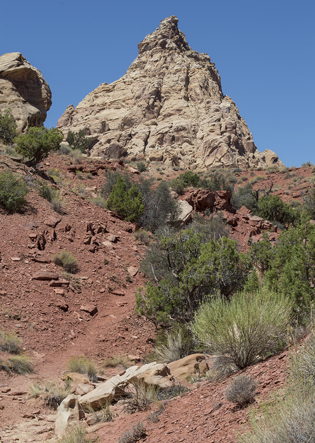
View of Devil's Castle

As you head toward the lake, you will come across many nice view of Devil's Castle, which lies just southeast of Cecert Lake, and Sugarloaf Peak, which lies just southwest of the lake. Both of these destinations can also be reached by starting along this trail. There is a faint trail on the east of the lake leading to the saddle between these two peaks, from which hikers can continue to either. Alternatively, there is a trail to the west of the lake that goes up Sugar Loaf Peak.


There is a fairly steady, gentle climb all the way to the lake, ending with a few switchbacks up a hill. After reaching the crest of this last hill, the lake comes into view.

Final ascent up small hill to the lake


Despite its namesake, this lake is anything but secret. This short trail is extremely popular among all age groups, and is likely to be crowded on weekends and holidays. We did this trail on Labor Day, and the shorelines quickly became packed with other hikers, youth groups, and families.


There are nice views of the lake and the surrounding area all along the trail that loops around the lake's perimeter.


Dogs are not permitted on this trail as this is a protected watershed area. Bicycles are also not allowed. There are restrooms available at the trailhead. There is also a campground near the trailhead.


Directions
This trail is located up Little Cottonwood Canyon in Salt Lake County, Utah. It is near the tiny resort town of Alta. To get there from the north, take I-15 to Exit 298 for the 1-215 Belt Route. From there, take Exit 6 for UT-190 toward 3000 E. Stay to the left (following signs for 6200 S), and then turn right onto Big Cottonwood Rd./UT-190. This road will become Wasatch Blvd. as you continue, and then UT-210/Little Cottonwood Rd.  Continue to the Alta Ski Resort, and then turn onto the maintained gravel Albion Basin Rd. Continue to the end of this road, where there is a parking area near the trailhead and the campground. Parking at Albion Basin is very limited, so you may need to park at Alta and take the free shuttle up to the trail head. The shuttle runs through the summer until about Labor day.

If you are coming from the south, from I-15 take Exit 291 for UT-71/12300 S. Head east along this road. It will change to become Draper Pkwy. and then 1565 E. Turn right when you reach Wasatch Blvd., and turn right again when you come to Little Cottonwood Rd. Continue up the canyon as explained above.

September 04, 2016

Ding and Dang Canyon/First and Second Canyon

The Trail
This trail is roughly 6.3 miles long with about a 662 foot elevation change, at least according to our GPS. It is recommended that adventurers travel up Ding Canyon and then down Dang Canyon, and that is the route detailed in this post. The trail is rated as difficult here due to the fact that it is a bit technical, but it is easy as far as technical routes go. This trail is only recommended for experienced hikers, and it is still suggested that you bring some rope and know how to use it. Since these are narrow slot canyons, the information from our GPS is not entirely accurate. I have tried to adjust the map below by deleting outlying points along the trail, but be aware that information in the below maps and graph are only approximate.

Topographical Map

Graph of Elevation

Trail in Google Earth

The trail starts by following a dry wash that splits about a mile in. To go up the northward Ding Canyon, take the right fork here.

Trail/Wash Split
Soon after this point, the trail will start involving some rock scrambling.


Then soon after this, hikers will see the canyon narrowing ahead of them.


When we did this hike in mid-August, we were told it had rained a couple days beforehand, and we came across a good amount of water we had to wade through. The water ended up being deeper than we were told it was likely to be, with it getting up to chest deep in a couple places in Dang Canyon. For those good at bridging, you probably can avoid these deep sections of water. However, while water levels vary, hikers should be prepared to get wet when doing this trail.


As you come out of Ding Canyon, hikers will see some rows of potholes (all of which are easily bypassed), as well as some interesting wind-pocketed rocks. The trail continues toward a unique looking peak with a bit of a curved point at its top that has been dubbed Ding Dang Dome. Ultimately, the trail passes just south-east of this peak before plunging down Dang Canyon.


Ding Dang Dome


The drops going down Dang Canyon are more dramatic than those found in Ding. Dang Canyon is not as scenic, but it provides more challenge. We found that there were ropes in place left by others in a couple spots, however that doesn't mean they are always there. Some obstacles may also be bypassed by staying up on the ledges.

Here is one of the ropes we found left in place at a dryfall

Dryfall with the rope from below

After a couple tall dryfalls toward the top of Dang Canyon, the walls close in more. There are a number of obstacles created by choke stones. The canyon is very narrow in places, and there are several water-filled channels. There are drops of about 10 feet in this section. If you attempt going the other way through these canyons, climbing up these drops is considered a 5.7 - 5.8 ascent.


Water-filled channel
After the canyon opens back up, it continues back down to the trail split, and then of course the wash takes hikers back another mile to the starting point.

Flash flood risks in these canyons is high. There are a lots of headwaters not visible from the trail for this area, so do not attempt this route in the case of thunderstorms.

There are no facilities at this trailhead, but there are vault toilets at the nearby Little Wild Horse/Bell Canyon Trailhead. There is no fresh water available at either trailhead though; the closest water is at the Goblin Valley Station/Visitor's Center. These canyons get a lot of sun and the area is hot during the summer, so bring plenty of water with you.

Directions
This trail is located in Emery Count, UT just outside Goblin Valley State Park. The closest town is Hanksville, followed by Green River. To get there from I-70, turn south onto UT-24. Next, turn west onto Temple Mt Road. Continue to Goblin Valley Rd. and turn left onto it. Continue to Wild Horse Rd. and turn right there. After passing Little Wild Horse/Bell Canyon Trailheads, you will need to continue another 1.3 miles to a large wash that will be on the right. Just before this area there is a sign stating that the road is no longer maintained. The road itself is in a wash, and your car will be in a flash flood area here, so again make sure that there is not a flash flood risk when you go. There is space to park around some cottonwood trees in this wash, and a little wooden sign was also posted here. Other than that, there are no other trail markings or indications.

Trailhead