September 07, 2014

Wind Caves

The Trail
This moderate trail is 1.9 miles one way with a 1010 foot elevation change. The trail leads up to the Logan Canyon "Wind Caves," which consist of some limestone arches. Interestingly enough, these arches weren't formed by the wind, but by water seeping through the rocks, eroding away the limestone, and creating underground caverns. Eventually, the Logan river cut away at the rocks, exposing the caverns underneath.

Topographical Map (Blue=main trail  Red=trail to view point)

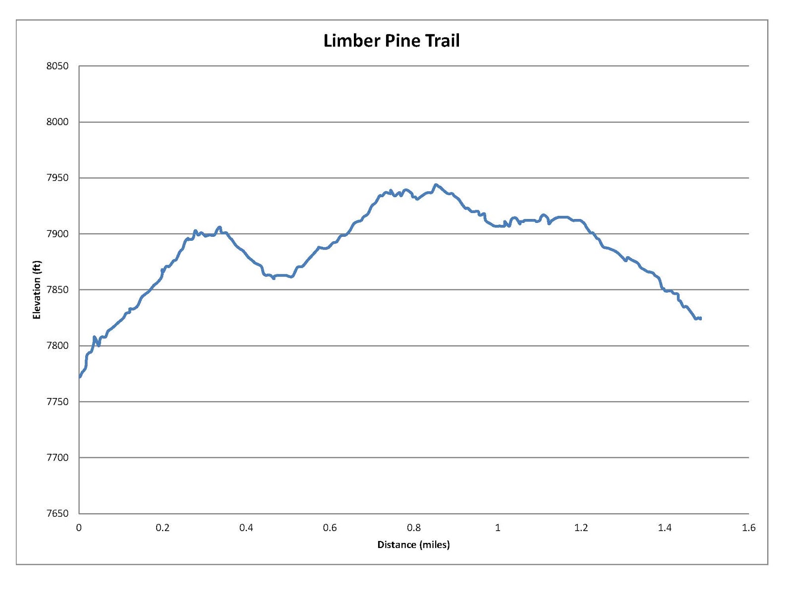
Graph of Elevation (does not include view point section)

Trail in Google Earth

The trail is pretty easy to follow, though there are some "short cuts" and other paths going off in some places. It is important to stay on the main trail to help prevent unnecessary erosion. There are some shallow caves at the point marked by a blue flag in the topographical map. As you near the Wind Caves, there is a turn-off that takes hikers to a nice view point of the caves. If you go to this point and back, it will add 0.1 mile to your total trip.

Looking at the Wind Caves from the view point

Visitors can walk through the caves; just beware of the steep cliffs at their edges.


This trail has some shade along the way, though how much really depends on the time of day you hike it. There will be more shade first thing in the morning or later in the day and less during the middle of the day. There are no restroom facilities available at the trailhead or along the trail. Dogs are permitted on the trail as long as they are kept on a leash.

Directions
This trail is located in Cache County up Logan Canyon. If you are coming from Logan, from Main Street turn east onto 400 North. Continue up 400 N/US-89 for about 7 miles until you reach the trailhead on your left. You will find it near the Guinavah-Malibu Campground.

If you are coming from Bear Lake, you again will follow US-89 up the canyon to the trailhead. The trail from this direction is about 31-32 miles up US-89.


August 31, 2014

Limber Pine Trail

The Trail
This easy trail is only 1.5 miles long round trip with a 170 foot elevation change. It is set up as a nature trail loop with plaques along the way with descriptions of various plants, natural forces, and similar topics. However, many of the plaques were quite weathered and otherwise damaged when we hiked this trail, making many of them difficult if not impossible to read.

Topographical Map

Graph of Elevation

Trail in Google Earth

This trail is perfect for families with young children and others who cannot go far. There are plenty of benches along the way to rest, and the trail doesn't have any steep or otherwise difficult spots. There is an outhouse available at the trailhead.

The trail is named after the old Limber Pine Tree, marked on the topographical map with a little tree. This tree is actually made up of more than one tree that all grew together. There are also some nice views of Bear Lake from the trail.

View of Bear Lake from the trail

Old Limber Pine Tree


Directions
This hike is located toward the Bear Lake side of Logan Canyon in Rich County, Utah. If you are coming from Logan, from Main Street turn east onto 400 North. Continue up 400 N/US-89 for 32-33 miles until you reach the trailhead on your right. There is a parking area here and the trail is marked. If you reach Sunrise Campground, you have gone too far.

If you are coming from Bear Lake, you again just follow US-89 up the canyon to the trailhead. You will arrive just after you pass Sunrise Campground.


August 03, 2014

Loafer Mountain Trail to Santaquin Peak

The Trail

Santaquin Peak is considered one of seven major peaks of Utah county. This moderately difficult trail is 5.8 miles long (one way) and has a 3,100 elevation gain. However, unlike the climbs to many peaks, there are a number of places where the trail descends some on the way up. While this adds a little to the overall amount of climbing hikers will do, it also spreads the climbing out and makes it less strenuous. The longest stretch of steep climbing takes place between mile 2.25 and 3.75.

Topographical Map

Close-up of first part of the trail


Close-up of second part of the trail

Graph of Elevation

Trail in Google Earth


The trail is easy to follow despite the fact that it is less popular than other peak trails. In fact, we were surprised to not run into any others hiking it on the day we went. There are a couple places where the trail seems to split, but most places it actually just joins back with itself. The Blackhawk Trail and Bennie Creek trails cross the Loafer Mountain trail about a mile into it, as marked by the blue hiker on the topographical maps, but the trails are well labeled. Just stay on the Loafer Mountain Trail, which is #98. There is also a gate a little ways after the trail split, which you must be sure to close behind you when you get there.

We hiked this trail starting early in the morning on July 24, and our timing was just right to see an amazing array of wildflowers in full bloom on the sloping meadows and along the mountain ridges. We saw lots of horse mint, yarrow, paintbrush, flax, and buckwheat, as well as blue bells, lupines, columbines, and forget-me-nots, among numerous of other blossom varieties.
 
A view of Mount Nebo from the trail

A sage grouse on the trail


Utah Valley from fire pit at the top of the steep steady climb (~ mile 3.75)

Although this trail is called the Loafer Mountain Trail, it actually does not go to the top of Loafer Mountain. Loafer Mountain Peak is said to be a couple feet higher than Santaquin Peak, but it is not a very angular peak. Santaquin Peak blocks the view of Utah Valley from the top of Loafer Mountain, so the view from Santaquin Peak is also considered to be better. Hikers wishing to get to the top of Loafer Mountain can continue up the ridge to its top, though there is not a trail in that direction.


Along the final accent to the peak

Mountain goats seen on the peak across from Santaquin Peak

When we reached the top, we found a tattered U.S. flag tied to a flag pole and a battered mailbox with moldy notebooks in which we could sign our names. The view all around us was fantastic though! From the top hikers can see a number of canyons, peaks, valleys, and other landmarks including Mount Nebo, Utah Valley, and part of Payson Lakes. Don't be surprised if you also spot some mountain goats.

Utah Valley from Santaquin Peak


Mount Nebo from Santaquin Peak

This trail is open to dogs that are kept on a leash and horses. However, as the trail approaches the peak there are rough spots that probably are not suitable for horseback riding. Also beware that there are not restroom facilities available at the trailhead or at any point along the trail.

View of Utah Valley on our way back after the sun came out more

Directions

This trail is located in Utah Valley along the Nebo Loop. If you are coming from the north, take I-15 to Exit 250. Turn left onto Main Street and continue to 100 North. Turn left on 100 North, then right on 600 East, and from there continue onto S. Canyon Rd./Nebo Loop Rd. The trail head is just over 8 miles up the canyon road at a parking area marked for the Loafer Mountain Trail.

If you are coming from the south, take I-15 to Exit 248 for Payson. Turn right onto 800 South, continue to 600 East, turn right and continue onto S. Canyon Rd./Nebo Loop Rd. Continue just over 8 miles to the parking area as explained above.

July 07, 2014

Bristlecone Trail (Great Basin National Park)

The Trail
This easy 1.5 mile (one way) trail has an elevation change of about 515 ft. It leads hikers past a glacial till and a view of the aptly named Brown Lake before arriving at a grove of ancient Bristlecone Pine trees. There are also some nice views of Wheeler Peak from the trail.

Topographical Map (blue = Bristlecone Trail; green = Alpine Lakes Trail)

Graph of Elevation

Trail in Google Earth (blue = Bristlecone Trail; green = Alpine Lakes Trail)

The trail head is actually found just up from the parking area after passing the nature trail. To stay on the Bristlecone Trail, stay left where it turns off from the Alpine Lakes Loop Trail (shown in green on the maps above). Once hikers reach the Bristlecone Pines, the trail makes a small loop through the grove. There are interpretive signs here labeling trees and explaining their characteristics. At the far end of this loop, the Glacier Trail (not shown) continues up the mountain for about another mile to the only glacier found in Nevada.


If you are not already planning to hike the full Alpine Lakes Loop Trail, it is well worth it to see the beautiful Teresa Lake before returning to your vehicle. You can get there by following the Alpine Lakes Loop trail as shown in green on the maps above. This will only add 0.2 mile to your hike with an extra 44 ft. elevation change. (Please note that the elevation graph shown above is only for the Bristlecone Trail and does not include Teresa Lake.)

Teresa Lake

Please beware that pets are not permitted on these trails.

Directions
This hike is located in Great Basin National Park in Nevada. From US-50, turn onto NV-487. Continue for just under five miles then turn right onto NV-488. After almost another five miles, turn right onto Wheeler Peak Scenic Drive. Continue to the end of this road right before entering the campground. There is a parking lot here from which you can access the trails in this area. The trails are well marked and well maintained.

June 29, 2014

Timber Creek Trail and South Fork Baker Creek Trails Loop

The Trail
This moderate loop trail is 5.5 miles long round trip with a 1734 ft. change in elevation. It is located in Great Basin National Park. This trail is shady for most of the way and very pleasant overall. We started along the Timber Creek Trail, so the elevation graph reflects that starting point.

Topographical Map

Graph of Elevation (starting from Timber Creek Trail)

Trail in Google Earth

The trail starts out crossing a couple bridges that go over the creek. In general, the trail from this direction gets slightly steeper as it continues along to the top. About 0.7 miles up, the Timber Creek Trail intersects with the end of the Pole Canyon Trail. The trail follows the narrow canyon until about 1.2 miles in, where a series of long switchbacks weaving in and out of the trees takes hikers up a hill. The trees open up into a meadow at the top of the hill. The trail then continues to the point it intersects with the South Fork Baker Creek Trail, about 2.6 miles up. A sign marks the different trails here. Continuing straight here will take hikers to Johnson Lake and the historic Johnson mines, but turning right takes hikers around and back toward the parking lot along the South Fork Baker Creek Trail. There are nice views of the surrounding peaks in this area, including Pyramid Peak.


Pyramid Peak

The South Fork Baker Creek Trail follows the creek pretty closely all the way down. The trail heads back into the trees, making it mostly shady once again. About 1.5 miles down from the Timber Creek Trail, the trail intersects with the north portion of the Baker Creek Trail. If you prefer a slightly longer hike, you could turn off here and still head back down the trail to the parking lot. We continued on the South Fork Baker Creek Trail all the way back.


There were a lot of wildflowers in bloom when we hiked this trail in mid-June, including shooting stars and columbines. All the wildflowers attracted lots of butterflies.


Pets are not permitted on these trails, but pack animals are so long as park regulations regarding them are followed.

Directions
This hike is located in Great Basin National Park in Nevada. From US-50, turn onto NV-487. Continue for just under five miles then turn right onto NV-488. From there turn left onto Baker Creek Rd., which is unpaved. Continue to the end of this road, which loops around. There is a parking area with an outhouse at the far end of this loop, and the trail starts here.