October 15, 2020

Upper Calf Creek Falls

The Trail

This moderate mile long trail (one-way) has about a 540 ft elevation change. The trail ends at a small pleasant waterfall dropping into a rocky pool.

Topographical Map

Graph of Elevation

Trail in Google Earth


The trail starts from a sandy parking area. Be careful where you park, especially if you don't have four wheel drive, as the sand is deep in some spots. From the trailhead, the path begins with a steep descent down slickrock that gradually gives way to a trail mixed with rock and sand. The canyon where Calf Creek runs is clearly visible from the top.

Trailhead

Heading down steep slickrock; notice
the line of shadow where the canyon runs

The trail grows less steep as it goes and levels off overall as it draws near the canyon and Upper Calf Creek Falls.

As the path cuts closer to the canyon rim, the alcove near Lower Calf Creek Falls can be seen, and soon after that the falls also appear.


Alcove near Lower Calf Creek Falls

Lower Calf Creek Falls

The trail takes hikers right up to the top of Lower Calf Creek Falls, but to view this waterfall from its base you must take a different trail.


Above the top of Lower Calf Creek Falls sits a series of pools feeding the waterfall.


Follow the water streaming into these pools a short distance further to find the much shorter Upper Calf Creek Falls at the far end of a larger pool.

Upper Calf Creek Falls

After reaching the pool and waterfall, hike back the way you came.

This trail is open to leashed dogs. There are no restrooms at the trailhead.


Directions

This trail is located in Garfield County close to Boulder, Utah. It is also not far from Escalante, Utah. From Boulder, the trailhead is about 5.6 miles south along Hwy 12 and will be on your right. It is not well marked from the road, so you will have to watch for it, however signs will be visible after you drive down the dirt road to the parking area. To get there from Escalante, drive about 21.5 miles along Hwy 12 from the middle of the town and find the trailhead on the left near the top of the ridge the road follows. It will be about 10 minutes/5.8 miles from the turn off for Lower Calf Creek Falls. GPS Coordinates: N37° 51.559' W111° 26.262'

Sign in the parking area

October 14, 2020

Petrified Forest and Trail of Sleeping Rainbows Loop

 The Trail

This moderate trail is about 2.2 miles round trip with a 250 foot elevation change. However, there is about twice as much climbing as the overall elevation change indicates due to the up-and-down nature of the trail. When I did this trail, I went counterclockwise around both loops, staying right at the intersections all the way through, so that is the approach shown on the graph and other information below. This is also the direction that hikers following the points of interest explained on the nature trail guide available to borrow at the trailhead.

Topographical Map

Graph of Elevation

Trail in Google Earth

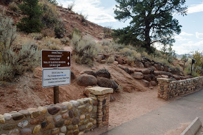
This trail starts on the other side of a short stone wall next to the parking area. It heads uphill with the help of a few switchbacks for about a half mile before leaving off some.

Trailhead

Another entrance to the trail

A short ways from the trailhead is an interesting rock balanced awkwardly at the edge of a drop-off. It stays suspended in the air by a small section that has not eroded away like the rest of the material under it.

Balanced Rock

Hikers will need to continue up through the pygmy forest and near the top of the hill before coming across any of the petrified wood that is abundant along this loop. A spattering of specimens lies along the sprawling landscape to the sides of the trail, but perhaps the most impressive along this section of path is a longer stretch of these fossils that appear to make up the broken segments of a once fallen tree.

Stretch of petrified wood segments

Right next to this line of petrified wood the path splits. In order to continue along the Trail of Sleeping Rainbows, stay straight as shown in the sign. When you come to the next sign, stay right to continue around the loop in a counter-clockwise direction. This trail descends down sharply, levels out some at the bottom near an overlook of the wash below, and then ascends back up an equally steep section before heading back to the main Petrified Forest Trail.

Trail Split

While The Trail of Sleeping Rainbows is not part of the main trail and nothing along it is included in the Nature Trail Guide, there are far more petrified wood specimens here than on the other trail. These incredible fossils literally line the path, and huge pieces present themselves at nearly every turn. I believe the largest pieces of  this wood-turned-to-rock are found along this section of the trail.


View looking down in the wash at the
west-most point of the trail

Very large pieces of petrified wood -
probably the largest I saw along the trail

Side view of the largest piece of petrified wood
I spotted on this trail

Heading back up the trail

After rejoining the main trail again, head right to continue that loop in a counter-clockwise direction. As you continue, enjoy the expansive views of the surrounding area. A sign post with the number twelve indicates the largest piece of petrified wood found along the Petrified Forest Trail (though there are larger specimens along The Trail of Sleeping Rainbows), and sign post 14 shows a remarkable specimen on which the tree rings are clearly recognizable.

Largest piece of petrified wood along the
Petrified Forest Trail

Remarkable Specimen on which the tree rings
are clearly visible

The trail ends where it starts after a descent along the same section of trail you came up. Enjoy nice views of Wide Hollow Reservoir and the surrounding area on your way back.


Either before you head up the trail, or after you get back, don't miss checking out the very long petrified tree fossil just north of the trailhead and parking lot!  

Long petrified tree near the trailhead

This trail is part of a state park and a fee is required to use the area. Restrooms are available as part of the park, but not directly at the trailhead. Leashed dogs are permitted on the trail as long as you clean up after them. This trail is under surveillance to help prevent theft of the rocks. Either way, please do not take anything with you from the park in order to leave it for others to also enjoy. (Furthermore, some say that a curse sticks with anyone who dares to steal the fossils from the area.)

Directions

This Garfield County trail is located only a couple of miles west from the center of Escalante, Utah. To get there, take Hwy 12 to Reservoir Rd. There is a clear brown recreation sign marking the turn off for "Escalante Petrified Forest State Park/Wide Hollow Reservoir." Turn north here and head past a rock shop and ranch land to reach the park. Stay right (away from the reservoir) where the road splits and head east a short ways to the parking area. GPS Coordinates: N37° 47.219' W111° 37.829'

October 13, 2020

Escalante Natural Bridge

The Trail

This easy trail is 2.2 miles (one-way) with only a 145 ft. elevation change. However, it does go directly through the river five times up to where we stopped. If you cross the river to get under the bridge, that is an additional crossing. To go there and back, be prepared to cross the river ten to twelve times total. Hiking sandals/water hiking shoes will work well for this.

Topographical Map

Graph of Elevation

Trail in Google Earth


The trail starts at a sign saying that you are entering the Escalante Canyon and that there is not really a trail. However, we found a pretty clear trail the entire way despite what this sign stated on the matter. In fact, hikers should do their best to stay on the existing path and particularly avoid going off into sandy off-trail areas. We noticed a number of areas of cryptobiotic soil along the trail, and in many places these delicate areas had footprints going through them. Please stay off of the cryptobiotic soil.

Trailhead

After only venturing a few yards down the sandy trail, hikers will meet their first river crossing. These crossings were not particularly deep while we were there, but there is not any ready way to get across them without getting your feet wet.


As the trail continues up the river, hikers are rewarded with beautiful views of the Navajo sandstone cliffs and slickrock domes that cap them. Depending on the time of year, you may also witness an abundance of wildflowers, lush green foliage fed by the river's waters, or the brilliant color of yellow fall leaves along the trail. There are some intriguing views of the red canyon walls and some other interesting rocks along the way.


Not long before reaching Escalante Natural Bridge, those who look up will be able to catch a glimpse of Skyline Arch high up on the canyon walls. I understand you can also hike much closer to it if you continue a short ways past where we stopped to view the ruins and accompanying petroglyphs. It is said to be about a half mile from the natural bridge.

Skyline Arch in distance

Escalante Natural Bridge pops into view soon after this above the trees, and continuing along the trail takes hikers right up to this alluring rock feature. Cross the river here to walk up under the sandstone bridge.


Continue another .04 miles to reach the Anasazi ruins. There is a social trail heading up off the main path that will take adventurers closer to these ruins and up to a petrogyph panel. Appreciate the artwork here, but please be respectful of the petroglyphs by not touching them or defacing the panel in any way.


After coming back down from the panel, you can continue up the canyon or you can return the way you came. This section of trail is about 16 miles long from the trailhead to Escalante. A short ways up from the panel is Skyline Arch, as previously mentioned, and Sand Creek, a tributary that descends down another beautiful narrower canyon.


Dogs are permitted on this trail, but be aware that there are no restroom facilities at the trailhead. Please be respectful of nearby private property as well.

Directions

This trail is located in Garfield County not far from Boulder, Utah. It is also not far from Escalante, Utah. From Boulder, the trailhead is about 12.5 miles south along Hwy 12 just before crossing the Escalante River. The trailhead will be just down a dirt road to the right before crossing the river. It is not well marked from the road. To get there from Escalante, drive about 14.5 miles along Hwy 12 from the middle of the town to the Escalante River and find the trailhead on the left right after crossing the river. GPS coordinates: N37° 46.545' W111° 25.174'