September 30, 2015

Burch Creek Canyon Trail

First/Only Bridge
The Trail
This moderate trail at least 2 miles long with about a 1400 foot elevation change. It is possible to continue up further than two miles, but we don't know exactly how far up the canyon a pathway exists. The trail follows the creek and crosses it a number of times. Only the first crossing has a bridge; the rest of the crossings require hikers to work their way across on fallen branches or stepping stones. None of these crossings were difficult, but they probably are more challenging during times of high run-off.

Topographical Map

Graph of Elevation

Trail in Google Earth


Start of the trail
The trail starts out wide, worn, and easy to follow. However, after the bridge, the trail narrows and becomes more rocky, but it is nothing unusual for the area. The trail continues to be clear and well worn until about 0.8-0.9 mile up the canyon, at which point the path becomes increasingly overgrown. Young children would probably have difficulty getting through some of the tall brush we started seeing around this point. By the time we got two miles up the path, we were finding that the path became sketchy in some spots. The entire trail runs through a forested area, so it is shaded by trees and shrubs. This hike makes for a very pleasant stroll especially with the shady trees and the peaceful babbling of the creek. Unlike some other trails nearby, this one doesn't seem to be very crowded even on popular hiking days, especially the further up you go.


Beware that the area this trail is in seems to be inhabited by a lot of rattlesnakes. We saw a few on or right next to the trail. The dense foliage along the trail makes it easy to miss them, so just be cautious. Make sure you know how to avoid being bitten and what steps to take in case of a bite.

One of the rattlesnakes we came across on the trail

This trail is open to livestock, leashed dogs, and bicycles. That doesn't mean that is would necessarily be a good trail for all those things though.

Update - May 2016: We were correct that this trail is less accessible during the spring. We dropped by briefly and found the first bridge was covered with cold water, as shown below.


Directions

This trail is located in Weber County, Utah in Ogden. To get there, from I-15 take Exit 339 for Riverdale Rd. Head east on Riverdale Rd./UT-26 until you reach 40th Street. Turn right onto 40th Street. This road will change to 4200 S/Country Hills Dr. Next, turn right onto Harrison Blvd., and then turn left onto 4600 S. 4600 S. will become Ridgedale Dr. You will first come to the Beus Canyon Trail. Continue on a little further and you will come to a brown gate on the left. This is where the trail starts. There is no parking lot, so you will have to park along the road. Just make sure you don't park in front of the fire hydrant or block someone's driveway.

September 20, 2015

Dooly Knob Trail

The Trail
This moderate trail is roughly 1.2 miles long (one way) with a 790 foot elevation change. If are hiking the Frary Peak Trail, adding this knob to your trail will add a total of 0.8 mile to your trip.

Topographical Map

Graph of Elevation

Trail in Google Earth


About 0.7 mile up the trail, at the top of the ridge, the Frary Peak and Dooly Knob Trails split.  The path is a bit less clear here than in most places, and we found that the sign at this point for Dooley Knob had been knocked over. Still, it wasn't difficult to find the right path heading north away from Frary Peak.

From the split, it is only another 0.4 mile to the end.


We were surprised how low the water level was there; it hasn't been that low during past trips we have made to the island.

View from the top
Dogs, horses, and bicycles are not permitted on the Frary Peak Trail. Also, be aware that the trailhead closes at 6:00 p.m. There are no restrooms at the trailhead, but there is a map.

Directions
This trail is located on Antelope Island in Davis County, UT. Traveling along the I-15 in Davis County, Utah, take exit 332 for Antelope Drive. Turn west onto Antelope Drive and continue straight until you reach the park entrance. There is a $10.00 entrance fee to access the park. After driving over the causeway and onto the island, keep to the left and keep going straight heading heading southward. The road will roughly follow the east shoreline of the island. Eventually, a road will turn off to the right that leads to the Frary Peak Trailhead. This is easy to find; the turn off is well marked and road directions on the island are easy to follow to this point. Continue up this road past a parking lot (for the Mountain View Trail), through a gate, and up to another large dirt parking lot. The trail starts at the end of the lot.

August 17, 2015

Sunset/Farmington Creek/Farmington Canyon Trail

The Trail
This trail seems to go by multiple names. I have seen it called the Sunset Trail, Farmington Creek Trail, and Farmington Canyon Trail. Whatever name you want to call it by, this moderate trail is 2 miles long (one way) with about a 1227 foot elevation change.

Topographical Map (white square marks cave; green flags mark falls
car symbols mark crashed cars)

Graph of Elevation

Trail in Google Earth

This trail runs below Skyline Dr. and just to the north of the creek. During the summer, there are some pleasant shady spot along the way. However if you do the trail in the middle of the day, the foliage is not tall enough to provide much shade along much of the trail.

We started this trail from the west end. If you also come from this end, very shortly after starting you will arrive at the very shallow Farmington Cave. This cave appears to be a popular spot for building fires and for spraying graffiti. It is marked on the topographical map with a white square.

Farmington Cave

Looking back down at Farmington Cave from further up the trail

Looking up the canyon from the trail
After continuing up the trail a ways, you will come to a stream crossing by a small waterfall. This beautiful and peaceful spot is about .9 mile from the trailhead. Some rocks offer nice seats for anyone who wants to take a break and rest in the shade.


Small waterfall at the stream crossing along the trail


By following the stream and climbing up the side of this lower waterfall, you will soon come to another small waterfall with a crashed car sitting above it.


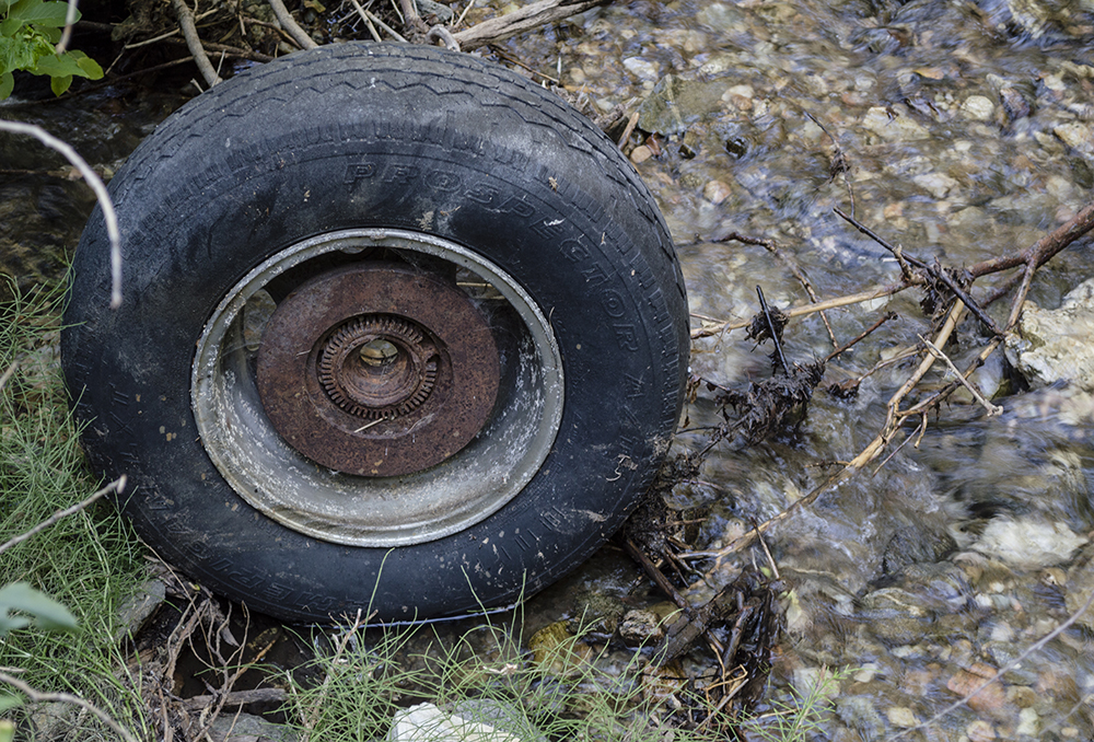
After continuing another 0.4 mile from this small waterfall you will come to another wrecked automobile. There are several of these vehicles from the 1940s, 50s, and 60s that came crashing down the canyon from Skyline Drive. The ones we saw are marked on the topographical map by little cars.


The vehicle below is the one furthest east on the map. We reached it by continuing a short way up a path heading east off the main trail (which turns more south) after the stream crossing here.


The large waterfall is about 1.6 miles from the trailhead where we started. Unfortunately, the view from the trail it is mostly blocked by trees. If you climb to the top of the nearby rocks, you can see the top of it a little better.


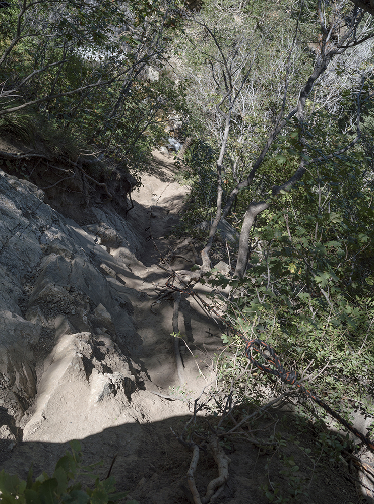
If you are up for some scrambling, you can climb down to the bottom of the cliff and see the waterfall from the base. This is a pretty steep path though, so use care. A rope had been placed there for some support when we hiked this trail in 2019, but the first time we went in 2015 there was no rope. As always for safety though, don't rely on any rope left on trails by others more than absolutely necessary, and always test them first.

Path down to base of waterfall
 

The waterfall is more impressive looking from the bottom. After enjoying the falls, you will have to head back up the way you came.

Climb back up to the trail


The trail continues after the waterfall for a little ways and then seemingly splits. The main trail turns and heads north taking hikers up a couple switchbacks to to a dirt road, which is as far as the maps above show. That dirt road continues up a couple more switchbacks to Skyline Drive near Sunset Campground. There is sign marking this end of the trail at the end of the small dirt road heading down to it, and if you prefer you could drive up the canyon along Skyline Rd. and start hiking from this point instead. Starting here, it is about 0.3 miles to the large waterfall.

Trailhead from the end of the little dirt road

The trail that continues southwest along the creek is shown in the topographical map in red. This is just a social trail following the river a bit further that eventually fades.

Directions
This trail is located in Davis County, Utah near Farmington. To get there, take Exit 325 off of I-15. Turn east onto Park Lane. Next, turn right onto Main Street and then turn left onto 600 North. Continue to 100 East/Farmington Canyon Rd. and turn left. Stay left on the paved part of the road when it forks (going right will take you to a parking area) to continue up the canyon. Right before the pavement gives way to dirt and the road turns sharply, there is a dirt parking area. Park here and you will find the trailhead on the north end of this parking lot. GPS Coordinates: N41 00.019 W111 51.984


August 10, 2015

Birdsong Trail

The Trail
This easy trail is only about 0.8 mile one way with about a 200 foot elevation change. There is an option to go out on an "overlook" trail (shown in green on the maps below) 0.3 mile from the trailhead at Rainbow Gardens, which will add about 0.1 mile to your trip. Either way, this trail is a well worn, fairly wide path that is perfect for a very short relaxing outing or for families with kids looking for something easy and interesting.

Topographical Map (Main trail=blue; Overlook=green; Path up Hill=red)

Graph of Elevation

Trail in Google Earth
(Main trail=yellow; Overlook=green; Path up Hill=red)

This pleasant trail cuts through some beautiful shady forested areas as well as some grassy open areas with nice views of the surrounding mountains and valley.


View from Overlook Trail at golf course below

Although the trail was pretty well marked, we accidentally went up a trail (marked in red on our maps) going straight up a hill. This is not part of the Birdsong trail and doesn't look like anything but a shortcut down to the trail from the houses above. If you find yourself going this direction, you are headed the wrong way.

View from shortcut trail up the hill
About 0.5 mile from the Rainbow Gardens trailhead, you will come to a nice resting spot with a bench nearby a little natural spring. This is a great place to listen to or spot birds especially during the right times of day - hence the name of the trail.

Natural Spring

Peaceful resting spot with bench

The trail continues to Fillmore Avenue near 20th street. There are nice views of the mountains and valley from here. There is also a picnic bench.

View from trailhead on Fillmore Avenue

This trail is also popular for bicyclists, so be polite and watch out for them if you are on foot.

Fillmore Ave. Trailhead
Directions
This trail is located in Weber County, Utah at the mouth of Ogden Canyon. To get there, take I-15 to Exit 344 for 12th Street in Ogden. Turn east and continue on 12th Street toward Ogden Canyon until you reach the turn for Rainbow Gardens at Valley Dr. Turn right here, and then turn left into Rainbow Gardens. The trailhead is at the far southwest corner of the parking lot.

Alternatively, you can drive up to Fillmore Ave and start the trail from there. To get to this trailhead from the Rainbow Gardens trailhead, continue along Valley Dr. to 20th Street and turn left. 20th Street will turn right and become 1300 E/Tyler Ave. Continue from there to 21st Street and turn left. Turn left again and Fillmore Ave. and continue to the end of the street where you will find the trailhead - GPS coordinates N41 13.866 W111 56.225.