June 26, 2021

Big Fill Loop Trail


 The Trail

This easy trail is a 1.6 mile loop with only about a 95 ft elevation change. The trail basically follows the Central Pacific and Union Pacific railroad grades to the Big Fill, with lots of informative points along the way.

Topographical Map


Graph of Elevation


Trail in Google Earth

Heading clockwise around the trail will follow the informative points in order. A explanation pamphlet can be bought from the visitor's center, but you call also call into each point on your cell phone to hear the point narrated.
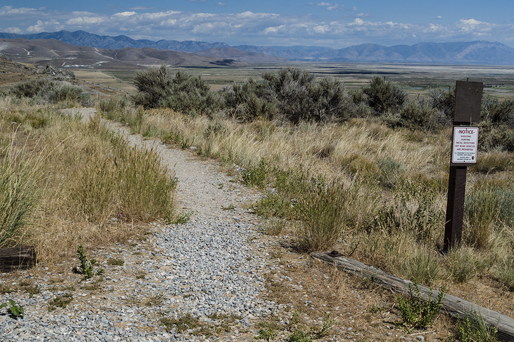
Trailhead

Going clockwise, the trail starts out following the Central Pacific grade. Since the two railroad companies couldn't agree on where to meet, and both were being paid based on how much rail they laid, they built two different tracks right past each other. The Central Pacific line created the more stable Big Fill to lay their track on, which was created from piled earth to fill in the area between hills for the tracks to run across. The trail arrives at the Big Fill about half way through the hike.

The Big Fill

Meanwhile, the Union Pacific company created the nearby less stable Big Trestle for their tracks to run on. It no longer is standing, but the dirt platforms from which it was built are still there.


Looking across the dirt platforms for The Big Trestle

Near the Big Trestle is a "false cut" where Union Pacific workers started making a cut into the rocks a little north of where they needed to. A few hundred yards south they made the cut in the correct spot.

On the other side of the loop on the way back toward the trailhead there is small cave (marked by green dot on the topographical map) that was probably used as a temporary shelter by workers during blasts.

Cave along the trail

Trail heading to the cave

This trail is open to dogs. It is fully exposed and thus quite hot during the summer; make sure you bring plenty of water. There are no bathrooms at the trailhead, but there are at the visitor's center. There is a fee to visit this trail since it is part of Golden Spike National Monument.

Directions

This trail is located in Box Elder County, Utah. To get there from I-15, take Exit 365 and head west on Promontory Rd. This road will become UT-83, and you will stay on this road for about 20 miles before turning left onto 7200 North. From this turn it is about 3.7 mile to the trailhead on the right. The parking is a little ways up a dirt road here. GPS Coordinates: N41° 38.238' W112° 29.490'

June 11, 2021

Deuel Creek Trail

The Trail

This moderate trail is roughly 4.5 miles round trip with about an 1335 foot elevation change if you stop where we did. The trail does go further though. We started at the North Deuel Creek Trailhead, went up the canyon along its north side, then came back down on the south side to the South Deuel Creek Trailhead. The dirt roads by the actual trail heads are very rough and the north one doesn't have good parking there, so it is better to park along the street below and walk up the road to the trail heads. The maps and elevation graph below reflect this route starting from 100 South and hiking the north side of the canyon first, then going down the south side.

Topographical Map (blue flag = rope swing)

Graph of Elevation

Trail in Google Earth
 

The trail starts out from the north trailhead going the hillside pretty steeply. After awhile though, the steepness tappers off some. The trail along here though is quite rocky and narrow in some spots.

Looking back on the north trail at a
narrow rocky section

About 0.8 mile up the trail hikers can either continue going east up the canyon or turn back west along the south side of the trail.

Campfire area along the north trail
just before the split


We went up the canyon a ways, as shown in the trail maps above. I am not sure exactly how far this trail continues up the canyon though since I have never continued to wherever this trail stops. This section of the trail is my favorite though. The temperatures are cooler here as the trail follows the babbling creek, crossing it on little log bridges at times. The trees make it quite shady too.

Thimble Berry in Flower


A mile and a half from the north trailhead there is a fun rope swing. If you start at the south trailhead, the rope swing is 1.7 miles up from the trailhead. Just above the trail to the north by the rope swing, a rock juts out a bit, and this is a popular place to jump off with the swing.

Rope Swing

Shortly after the swing (about another tenth a mile) there is a nice large campsite. Somewhere soon after that there is supposed to be another waterfall, but we didn't find it. We probably needed to go a bit further, but we were out of time.

When heading back, we took the trail on the south side of the canyon, which stays by the stream and passes by a small waterfall. If you just want to hike to the point of the waterfall, it is about 0.9 mile from where we started up the road, or about 0.4 mile from the south trailhead.


After reaching the south trailhead, we continued back to our car by way of connecting hiking trails. This is shorter than following the main roads. The trail heading down from the parking lot by the south trailhead is on the northwest side of the lot. From here, keep heading back toward 100 S.

Follow the arrow pointing left here


This trail is open to dogs. If you bring children with you, just be aware there are a couple spots where the trail is very narrow and the drop offs are steep and slippery.


Directions

This trail is located in Davis County in Centerville. From I-15, take Exit 319 for Centerville. Turn east onto 400 North/Parrish Ln. Continue to 400 East and turn right. Then turn left onto 100 South and go to the end of the street. Unless you have an all-terrain vehicle, you will probably want to walk from here up 850 East. There are no trail markings here, nor are there any trail markings until you actually reach the trail heads.

At the top of this narrow paved road, everything turns to dirt roads. You will see fences and private property signs along these roads. To get to North Deuel Creek Trailhead, turn left and walk until you find the trail head, which is at about N40 55.043 W111 51.824. To get to South Deuel Creek Trailhead, turn right where the road splits and continue until the road splits again. Turn left at the second split and continue to the south trailhead, which is at about N40 54.940 W111 51.676.

June 07, 2021

Moonflower Canyon Trail

The Trail

This easy trail is only 0.4 miles one way with a 40 foot elevation change. It heads up a short canyon to a small pool, making it a nice walk for a picnic lunch or just to relax for a bit.

Topographical Map
Graph of Elevation

Trail in Google Earth

Some people we saw headed up this trail in swimming suits, but the pond was quite small and not really worth swimming in while we were there. The size and depth of the pool can vary widely though. In fact, after a good rainstorm a waterfall drops water into the pool. There are also petroglyphs at the mouth of the canyon; please be respectful and do not deface or touch them. Please don't deface the rocks all at in fact...leave them for others to also enjoy.


Small pool at end of the canyon

The trail actually splits and branches out a lot, but most of the trails seem to reconnect and head the same place. Beware of poison ivy though.

Leashed dogs are permitted on this trail. Vault toilets are located at the campsite at the mouth of the canyon, but those really are for the campsite.

Directions

This trail is located near Moab, Utah in Grand County. To get there from US-191, turn and onto Kane Creek Blvd., located on the south end of Moab, and head west. Continue for 2.3 miles on this road until you come to the trailhead on your left.

Alternatively, if you are already coming from the north side of Moab, turn off onto 500 West, and then turn right onto Kane Creek Blvd. and continue as explained above. GPS Coordinates: N38° 33.252' W109° 35.233'

June 05, 2021

Long Bow Arch Trail/Bow and Arrow Route

The Trail

This moderate trail is 1.3 miles long one-way to get to Long Bow arch with a 430 ft. elevation change. It involves a number of other points of interest along the way as well from dinosaur tracks to petroglyphs. This trail is shown in blue on the maps below. However, for those wishing to do the Bow and Arrow canyoneering route, a 2.5 mile loop can be made past Long Bow arch, down the rest of the canyon, and then walking back up the road to the trailhead. This technical route is shown in red in the map below and involves 4 rappels, marked by the blue flags.


Topographical Map (Blue=Long Bow Arch Trail; Red= Bow
and Arrow Route)
Graph of Elevation (Long Bow stops at 1.3 miles in)

Trail in Google Earth

This trail starts at the Poison Spider Trailhead (an ATV road) at the opposite side of the parking area. It starts out with some switchbacks climbing up first to a panel of dinosaur prints and then past a few petroglyphs.

At the trailhead for Poison Spider

Long Bow Arch Trailhead

Dinosaur Foot Prints

Petroglyphs

Keep your eyes out of additional petroglyphs along this trail; there are many, but I didn't take pictures of all of them. From here, continue along the side of the rock wall until you reach a small narrow arch. The trail heads right up below the arch via some metal pieces that have been bolted in the rock here to create a ladder of sorts.

Trail heading up by small arch

Small arch from opposite side

After heading past the arch, follow the green painted marks on stone to stay on the trail. The area opens up into a wide canyon before heading west into a narrower canyon. As the trail turns off, Long Bow Arch is visible ahead.

Trail through open canyon area

Approaching Long Bow Arch from trail

Long Bow Arch sits 1.3 miles from the trailhead. It pulls out gently from the rock wall behind it while boasting about 60-80 foot long span.


For those hiking the trail, simply turn and head back along the trail the way you came after enjoying the arch. Dogs are permitted on this trail, and there is a vault toilet at the trailhead.

For those wanting to engage in some canyoneering, continue up the canyon to the technical sections. Soon you will come to a high point and then start to descend. Shortly after the start of the descent, adventurers will arrive at the first short rappel point.

Looking down the canyon. Across the way
are other cool places to explore like
Pool Arch. Further back are the
La Sal Mountains.

Three tenths of a mile later, you will arrive at the anchor for the second rappel point, which consists of about a 120 ft. drop.

Looking out at the top of the second rappel point

Looking at the second rappel from
its bottom

Continuing down the canyon, in a additional two tenths of a mile there is a low angle 60 ft rappel. Very shortly after, you will come to the final rappel, which is roughly 75 ft.

Small pool along the route.

Looking down the low angle rappel. Right
after this one is the last rappel down to
the road.

Final Rappel

From the bottom of the last rappel, you can make your way up the road back to the trailhead. It is roughly a half mile walk.

Directions

This trail is located near Moab, Utah in Grand County. To get there from Moab, head north on US-191 and turn southwest onto UT-279. Continue for 5.9 miles on this road until you come to the trailhead on your right. The road curves around and there is a dirt parking area here. The trail starts on the far north side of the parking lot. GPS Coordinates: N38° 31.960' W109° 36.533'

June 04, 2021

Rock of Ages/Pool Arch Route

The Trail

This moderate technical route requires some class three climbing/rock scrambling and involves 2-3 rappels. The canyoneering route is about a 4.5 mile loop with about a 727 ft. change in elevation.

Topographical Map
Graph of Elevation

Trail in Google Earth

This trail starts up Pritchett Canyon ATV Road (requiring a fee to cross the private ground in front of this road). After a half mile, adventurers must turn left up the narrow side canyon. Head up this canyon, watching out for poison ivy as you go. The canyon appears to dead-end from a distance, but as you get closer it becomes apparent that you can climb up this gully and continue.

Trail Entrance - entrance fee paid here to cross private land

Pritchett Canyon ATV Road - head up this
for about a half mile

Turn off for Rock of Ages Route into
side canyon

Looking back down on the climb up
the narrow gully


There is a fairly clear trail that continues here. As always in this sort of terrain, be sure to stay on the trail and/or rocks to avoid destroying cyrptobiotic soil along the way. Look back along the way to see this jug handle arch.

Walking up a ways further will bring adventurers to another gully to climb up.


Another spot to climb up

As the terrain opens up more, you will come upon the first spot to rappel about two miles into the trail. You can see the spot in the first picture below where a group is waiting below to descend. Right behind the rappel spot sits Pool Arch. There is webbing on a tree here set up for the rappel, but you could also use one of the other trees nearby (as we did since a very large group was using the first tree).

Coming up to the first rappel

Pool Arch

Alternatively, the first rappel can be avoided by keeping right to climb down a gully to pool arch as explained here. In fact, using this gully to go up and down to retrieve ropes is recommended in order to avoid rope grooves.

If you do choose the route going down the rappel, it is about a 130 ft/40 meter drop. (That being said, I have seen other places saying it is closer to 160 ft., but according to our GPS it is much closer to the places that have said 130 ft.) After the descent, make your way through the narrow V opening in the rocks under the arch and into the pool of water. Wade or swim off to the left to continue the route.

First Rappel

Head through the V opening into the
pool of water


As you come out of the pool, continue east for a short distance before turning south into the canyon that will then loop back in a westward direction.

Looking east after the pool. Don't continue on in this
direction; turn south.

The canyon narrows significantly and leads through some tight spots requiring a bit of maneuvering to comfortably pass.

Bridging across this pool works best

We found it easiest here to not use the
hanging strap but to sit on the second
knob and slide over to the foothold on the
other side. Climb down and wade
through the water.

After 0.4 mile from the first rappel, you will reach the second rappel point, a drop of about 50 ft/15 meters. Anchors are set up in the middle of this for rappelling. From this point, the route heads through a beautiful, more open, high walled canyon area.


Flowering Prickly Pear

In another 0.4 mile from the second rappel, you will arrive at the final rappel point. There are multiple anchor options for this rappel, the higher ones requiring a bit more rope than the lower. The lower anchor involves climbing down a bit to find off to the right side. This rappel down to an alcove is about 100 ft/30 meters, but plan on some extra rope for the higher point.

Final rappel point


From here, simply continue following the path out of the canyon and back to Pritchett Canyon, then walk down the ATV road back to the trailhead.


Looking back into canyon where route exits

Heading back down Pritchett Canyon

Directions

This trail is located near Moab, Utah in Grand County. To get there from US-191, turn and onto Kane Creek Blvd., located on the south end of Moab, and head west. Continue for 3.8 miles on this road until you come to the trailhead for Pritchett Canyon on your left. This is located shortly before the road turns to dirt. There is parking here, and more parking about 0.1 mile up the road.

Alternatively, if you are already coming from the north side of Moab, turn off onto 500 West, and then turn right onto Kane Creek Blvd. and continue as explained above. GPS Coordinates: N38° 32.112' W109° 35.977'