July 10, 2013

Puffer Lake to Big Johns Flat via Puffer Lake and Skyline Trails

Trail

This moderate trail is about 6 miles long one way with about a 1255 foot elevation change. Keep in mind though that there is some up and down within the trail. More importantly, even though this trail is only moderately difficult based on elevation changes and terrain, it is difficult to follow as it does not seem to be well marked or maintained in places. This is especially true of the Puffer Lake Trail (Trail 175).


Topographical Map of Full Trail

Graph of Elevation

Trail in Google Earth

We started at Puffer Lake at an ATV trail. Our Fishlake National Forest map shows a hiking trail stemming from this same area and going more directly over to the main Puffer Lake Trail from the Cullen Creek Rd. However, we didn't see it. If it is really there, I believe it starts further up the road.

Puffer Lake

The ATV trail ended up taking us back toward the main road. The ATV trail ended abruptly at the trail head for the Puffer Lake Trail. We found a trail marker at this point and the trail turned and headed in a northeast direction. It had a steady but not overly steep incline and was pleasantly shaded since went through the forest. While the trail did not seem extremely well used, we managed to follow it without too much trouble until we reached and opening where the trail intersected with the ski resort's ATV trails, about 1.5 miles from our starting point. The in the middle of this area is a metal box. (Because nothing was well marked, we ended up following the ATV trail at this point heading north down the hill - marked by the white trail in the maps - and ended up at the ski lift. We realized we were not on the trail and had to go back up the hill to find the right trail.) When reaching this point, make sure you continue straight along the ridge and do not take the ATV trails. The actual Puffer Lake Trail probably will not be immediately visible, but as you continue it will appear again.

Topographical Map of Puffer Lake Trail (white trail = ATV ski lift trail)

View from open area at metal box

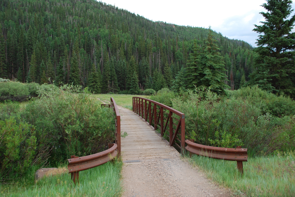
From here the trail was pretty easy to follow until we reached and crossed the creek (the creek is marked by the blue diamond shapes on the topographical maps). Immediately after crossing the creek (at about N38 20.415 W112 21.624), the trail disappeared almost entirely. We managed to find a leaning wooden beam in the middle of some rocks, but any sign it might have held at one point was gone. We continued to head west looking for signs of the trail without much luck. Eventually we noticed a wooden bridge or walkway up by some pine trees above us (marked by the green flag in the topographical maps at about N38 20.514 W112 21.771), so we continued up to that point where we found the Skyline Trail.

Topographical Map of Skyline Trail

Wooden bridge/walkway by which we were able to find the Skyline Trail
After continuing northwest along the Skyline trail for a little ways, we found a sign apparently marking the intersection of the Skyline and Puffer Lake Trails. However, the Puffer Lake Trail seems to get lost in the meadow not long after this sign. The sign itself was broken with a piece of it lying on the ground, which we picked up and placed back on the sign.

Sign marking the intersection of Puffer Lake and Skyline Trails

View from junction of two trails. Downhill path is the white ATV trail on maps

After you reach the Skyline Trail, the trail is easier to follow, although it too has a couple rough spots. It seems that the Skyline trail at the north where the trail head is shown on the above maps has changed at times. We ended up on a section of the trail that according the markers we saw is now closed.  We still found the trail head, but not by the main route. Therefore I have adjusted the trail shown in the maps to where I believe this trail is supposed to be. Just be aware that it may not be entirely accurate though. There are outhouse style restrooms at the Big Johns Flat trail head.

Overall, this is a beautiful trail that is pleasantly cool in the summer due to its high elevation. Hikers will find a great mix of shady forests, open meadows, colorful wildflowers, expansive mountain views, and babbling brooks as they transverse the trail. Dogs and livestock are permitted on these trails.


I would not recommend attempting this trail route though without a map and GPS or compass. Knowing what to expect of these trails ahead of time should also help. For a map of the area, you can go by the Beaver Ranger District Office at 575 South Main Street in Beaver. They will give you a "free" map courtesy of your tax dollars. Just beware that the personnel there did not give us accurate trail lengths. The trails ended up being longer than we were told.


Directions

This trail is located near Beaver, Utah up Beaver Canyon in Beaver County. When coming from the north, to get there from I-15 take exit 112 for Beaver. Turn left onto Main Street, and then turn left onto 200 North/UT-153. If you are coming from the south, take exit 109 off I-15, turn right onto Main Street, and then right onto 200 North/UT-153. Continue up UT-153 for about 21 miles. This will take you up Beaver Canyon and into Fishlake National Forest to a dirt road on your left. Turn onto this dirt road, called Cullen Creek Rd. It will be labeled with signs for Puffer Lake. Continue up this road about 0.4 miles to reach the ATV trail we started on as shown on the above maps.

Alternatively, to start from the other end of this trail, go up UT-153 for about 16.3 miles and then turn left onto Sunset Dr., which is a gravel road. Stay left at the fork to head to Big Johns Flat. Continue another 4.5 miles to reach the trail head (N38 21.541 W112 23.570). Beware that it may be more difficult to start the trail from this end and then find the Puffer Lake Trail from the Skyline Trail if you don't know where to look.

July 09, 2013

PST 05 to Three Creeks Reservoir

The Trail

This easy trail is 1.4 miles long with a 313 foot elevation change. It is actually an ATV trail and can by used by motorized vehicles 60 inches wide or less. However, hikers are also welcome to use the trail. In fact, this trail is just so beautiful you may get much more out of walking up it instead of riding across it on an ATV. The trail's numeric title doesn't do it much justice.

Topographical Map

Graph of Elevation

Trail in Google Earth
We started this trail from the west side and hiked up towards Three Creeks Reservoir. The trail starts out by crossing a bridge and then turning into the short canyon with a little creek running through it. It is a lush green area with mossy rocks, tiny waterfalls, and various wildflowers. You may also see small beaver dams and their residents. As you continue up the canyon, the rocky canyon wall will rise up immediately to the north of the trail.

Bridge at the west end of the trail


The ends near the dam for Three Creeks Reservoir. At this point the trail gradually widens into a dirt road as it goes up a switchback. We hiked to the fork in the road overlooking the reservoir, but the dirt road does continue to the main road (making it possible to hike from one end of this trail to the other if you have more than one vehicle available).


Directions

This trail is located near Beaver, Utah up Beaver Canyon in Beaver County (yeah, I know...that is a lot of beaver...). When coming from the north, to get there from I-15 take exit 112 for Beaver. Turn left onto Main Street, and then turn left onto 200 North/UT-153. If you are coming from the south, take exit 109 off I-15, turn right onto Main Street, and then right onto 200 North/UT-153. Continue up UT-153 for about 14.7 miles. This will take you up Beaver Canyon and into Fishlake National Forest. Park at the Jimmie Reed trail head, which will be on your left. Outhouse style restrooms are available here. Cross the street to find the trail head for PST 05.

Alternatively, to start from the other end of this trail, go up UT-153 for about 17 miles and then turn right onto the dirt road. There is a sign here for the Beaver High Adventure Base. Continue on this road until you reach the fork in the road at N38 17.883 W112 25.266. This is where we ended our trail, but if desired you can stay right and drive a regular vehicle further down to the base of the dam.

July 08, 2013

Upheaval Dome Trail - Canyonlands

The Trail

This easy trail is 0.8 mile one way and has an elevation change of about 107 feet. The trail leads to two different view points that look into Upheaval Dome. The first is roughly 0.3 mile up the trail and the second is at the end of the trail.

Topographical Map

Graph of Elevation

Trail in Google Earth

Upheaval Dome itself is a mysterious crater type formation over two miles wide that has been eroded away at one side. While there are theories about the explanation behind it, no one knows for sure what created it.

Upheaval Dome from the first overlook

Looking down Upheaval Canyon from the second overlook

Upheaval Dome from the second overlook

Directions

This trail is located in the north most end of San Juan County in the Island in the Sky District of Canyonlands National Park near Moab, Utah. To get there, turn west off of US-191 onto UT-313. This will be marked with signs for Canyonlands. You will have to pay a fee to enter the park either at the station along the road or at the Visitor's Center. From the Visitor's Center, continue about 6 miles to the fork in the road and turn right. Continue to the end of this road to reach Upheaval Dome.

Mesa Arch Trail - Canyonlands


The Trail

This easy loop trail is only 0.5 mile long with a minimal 80 foot elevation change. The short trail takes hikers to the low lying but long Mesa Arch.

Topographical Map

Graph of Elevation (very rough)

Trail in Google Earth

When looking through the arch, hikers will see the La Sal Mountains. This is a great place to watch the sunrise.


Directions

This trail is located in the north most end of San Juan County in the Island in the Sky District of Canyonlands National Park near Moab, Utah. To get there, turn west off of US-191 onto UT-313. This will be marked with signs for Canyonlands. You will have to pay a fee to enter the park either at the station along the road or at the Visitor's Center. From the Visitor's Center, continue about 6 miles down the road. The turn off for Mesa Arch will be on the left a little before the road splits.

Grand View Point Trail - Canyonlands

The Trail

This easy trail is 0.8 mile long with only a 60 foot elevation change. The trail starts at Grand View Point Overlook in Canyonlands National Park and continues out along the ridge allowing hikers nice views of the surrounding landscape and the interesting geological features found in this area.

Topographical Map

Graph of Elevation

Trail in Google Earth

The trail is at the very southern tip of the Island in the Sky Mesa. Hikers looking out from the view points along the trail will see Monument Basin, Junction Butte, and the La Sal Mountains off in the distance.

View from Grand View Overlook Point at Monument Basin

Junction Butte

The trail ends with some boulders and rock formations. These can be climbed for a stunning 360 view of the surrounding landscape.

Large boulders & rock formations at end of the trail

Mounument Basin from the end of the trail


Looking back at the overlook point from the trail

Directions

This trail is located in the north most end of San Juan County in the Island in the Sky District of Canyonlands National Park near Moab, Utah. To get there, turn west off of US-191 onto UT-313. This will be marked with signs for Canyonlands. You will have to pay a fee to enter the park either at the station along the road or at the Visitor's Center. From the Visitor's Center, continue about 6 miles to the fork in the road and turn left. Grand View Point Overlook and the trail head are found at the end of this road.

Corona Arch Trail

The Trail

This moderate trail is about 1.4 miles long one way with a 415 foot elevation change. The trail starts out up a few short switchbacks and then crosses a railroad. This railroad is used to transport potash from the nearby potash mines. As the trail continues on, much of it is on slickrock. There is a section that requires climbing up footholds in the slickrock, with chains to hold onto for additional support, and after that there is a ladder to ascend.

Topographical Map

Graph of Elevation

Trail in Google Earth

This trail actually leads to two arches. The first is the Bowtie arch. This arch is found high up on the cliffs. Hikers can up under this arch if desired.

Bowtie Arch
The second arch is Corona Arch, also known and Little Rainbow Arch. This impressive arch marks the picturesque end of the the trail.


This arch is also great for repelling down. There are bolts at the top for this purpose. Those interested in repelling down can climb up the steep buttress rock projecting from the cliff. There are some steps carved into the rock here, but the climb is steep and exposed, so use caution. Going down is more difficult than going up this way. There are some pitons in the rocks here for those wanting to use ropes for the climb. After climbing up the buttress, it is not hard to follow the cliff ledges over to the arch. The descent is 140 feet, with 120 feet in which adventurers will be free hanging.

Others have chosen use ropes to create a giant swing off this arch, but this can be particularly risky.


Between the arch and the buttress the formations in the rock make it look as if there is a face on the cliff wall.


Directions

This trail is located in Grand County very near Moab, Utah. To get to the trail head from US-191, turn off at UT-279. Continue for about 10 miles on this road until you reach the trail head, which will be on the right. This road will also pass by a stretch of popular climbing spots on the way.