This moderate trail has a 1479 foot elevation change and is about 5.3 miles long (round trip). The Curly Springs Trail is actually just the trail that crosses in front of Big Baldy. To get to this trail, you must first travel up Battle Creek Canyon or Dry Canyon. When doing this hike, we started up the Dry Canyon Trail and then went down Battle Creek, so the elevation graph and descriptions below reflects that route.
 |
| Line of trees on ridge near turnoff for the viewpoint |
You will find Curly Springs itself a little while after turning onto the trail (as marked by the blue flag on the map below). This is a good place to let your animals get a drink.
 |
| Topographical Map |
 |
| Graph of Elevation |
 |
| Trail in Google Maps |
Right before the Curly Springs Trail turns and starts its descent into Battle Creek Canyon, there is a split in the trail. If you go off the main trail here you will head up to the top of the ridge where there are some great views of Rock Canyon, Mount Mahogany, Mount Timpanogos, Big Baldy, and Utah Valley. Going to this view point and back adds .5 miles to the trail. This slight detour is definitely worth the effort though, and the distance and elevation are included in the overall information for this trail.
 |
| Battle Creek near where trails connect - this intersection used to be poorly marked |
Most of the trail up to this point is open, but as descent starts into Battle Creek Canyon, the trail dips into a cooler wooded area. The trail then crosses Battle Creek itself and connects with the trail named after it. If you are completing this trail in the opposite direction, coming up Battle Creek and down Dry Canyon, the intersection used to be very difficult to find. However, it has since been improved with clear trail signs and markers.
 |
| Trail sign marking Battle Creek intersection |
 |
| Looking at Curly Springs Trail turn-off from Battle Creek Trail |
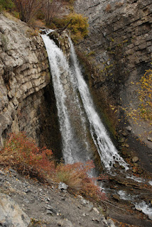
The Battle Creek Trail follows the creek down to the the mouth of the canyon. (If you were to head up it, this trail would also connect with the Timpanogos Perimeter Trail and the trail to the top of Big Baldy.) Be prepared to cross the creek several times on the way down. Some spots have bridges or other implements to help hikers cross, but other spots don't have much along those lines. This presents more difficulty in the spring during high run off than in the fall though. About .8 miles down the trail you will find the 50 foot tall Battle Creek Waterfall (marked by a blue flag on the topographical map). From here is is about .6 more miles to the Battle Creek trail head.
This last portion of the trail makes a nice short hike in and of itself that is suitable for families. It is especially nice in the summer to take that little trek up to the waterfall and play in the water below.
These trails are open to animals. There are also some campsites available for backpackers along the way. Restrooms are available at the trail heads.
 |
| Heading up Dry Canyon |
 |
| Looking up Dry Canyon Trail toward Timpanogos at the trail split |
 |
| View of Timpanogos and Big Baldy from the view point |
 |
| Battle Creek Fall |
 Directions
This trail is found in Utah County. If you are starting from Dry Canyon (as we did), from I-15, take Exit 273 for Lindon/1600 N Orem. Head east on 1600 North until you reach 400 West. Turn left on 400 West, then turn right on 2000 North/200 South. Continue up the hill to the to the top of 2000 North, then turn left onto Dry Canyon Dr. Follow the road up to the parking lot where you will find the trail head. GPS Coordinates: N40° 20.498' W111° 40.601'
If you are trying to reach the Battle Creek Canyon trail head, from I-15, take Exit 275 for Pleasant Grove/Lindon. Head roughly east on Pleasant Grove Blvd. to State Street and turn right. From State Street, turn left onto 200 S/Battle Creek Dr. Continue straight up this road until you reach the park at the end. The trail starts from the park. GPS Coordinates: N40° 21.786' W111° 42.046'

No comments:
Post a Comment